IMAGES TAKEN NEAR TO
Victoria Road, RICHMOND, DL10 4AU
Introduction
This page details the photographs taken nearby to Victoria Road, DL10 4AU by members of the Geograph project.
The Geograph project started in 2005 with the aim of publishing, organising and preserving representative images for every square kilometre of Great Britain, Ireland and the Isle of Man.

There are currently over 7.5m images from over14,400 individuals and you can help contribute to the project by visiting https://www.geograph.org.uk
Image Map
Images are licensed for reuse under creativecommons.org/licenses/by-sa/2.0
Notes
- Clicking on the map will re-center to the selected point.
- The higher the marker number, the further away the image location is from the centre of the postcode.
Image Listing (223 Images Found)
Images are licensed for reuse under creativecommons.org/licenses/by-sa/2.0
Image
Details
Distance
1
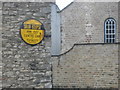
Old circular AA sign on the A6108 Victoria Road in Richmond
Old AA Sign on the southwest facing wall of No 1 Quakers Lane on the A6108 Victoria Road. Richmond parish.
This is a special commemorative circular sign not quite conforming to the other two circular styles.
There were five series of AA signs, mostly dating from 1923 and made by Francis & Co / Franco in Deptford, London. The village name and distance to London were usually displayed.
See also https://www.geograph.org.uk/photo/7300505 , https://frenchcarforum.co.uk/forum/download/file.php?id=8107&sid=1d14a1cd5a3d419f0f4dea48ad20a58b&mode=view and https://www.flickr.com/photos/richardbarron/6975919716.
Milestone Society National ID: YO-RICH
Image: © Milestone Society
Taken: Unknown
0.01 miles
2
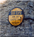
Solar Eclipse, June 1927
The yellow AA sign marks the centre line of totality.
Image: © David Rogers
Taken: 14 Oct 2009
0.01 miles
3
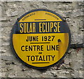
![Richmond features [34]](https://s3.geograph.org.uk/geophotos/07/30/05/7300503_2547e149_120x120.jpg)
Richmond features [34]
Attached to number 1 Quakers Lane is this unusual plaque, seen closer at Image, showing the centre line of totality of the solar eclipse of June, 1927.
Richmond is a picturesque market town in North Yorkshire, some 13 miles northwest of Northallerton and about 11½ miles southwest of Darlington. Set on the north bank of the River Swale, the town is on the edge of the Yorkshire Dales National Park, and is marketed as the Gateway to the Dales. Richmond was founded in 1071 and the castle was completed in 1086. Tourism is important to the local economy, as is the influence of the nearby Catterick Garrison army base. A traditional market operates every Saturday in the large cobbled marketplace.
Image: © Michael Dibb
Taken: 19 Jun 2022
0.01 miles
4
![Richmond features [35]](https://s1.geograph.org.uk/geophotos/07/30/05/7300505_b56dd988_120x120.jpg)
Richmond features [35]
A closer look at the plaque seen at Image
Richmond is a picturesque market town in North Yorkshire, some 13 miles northwest of Northallerton and about 11½ miles southwest of Darlington. Set on the north bank of the River Swale, the town is on the edge of the Yorkshire Dales National Park, and is marketed as the Gateway to the Dales. Richmond was founded in 1071 and the castle was completed in 1086. Tourism is important to the local economy, as is the influence of the nearby Catterick Garrison army base. A traditional market operates every Saturday in the large cobbled marketplace.
Image: © Michael Dibb
Taken: 19 Jun 2022
0.01 miles
5
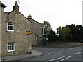
Solar Eclipse, Richmond
At the junction of Quakers Lane and Victoria Road.
Image: © David Rogers
Taken: 14 Oct 2009
0.01 miles
6
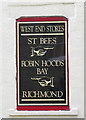
Coast to Coast, Richmond
117 miles from St Bees and 73 miles from Robin Hoods Bay.
Image: © David Rogers
Taken: 14 Oct 2009
0.02 miles
7
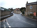
Westfields (A6108), Richmond
Looking north west.
Image: © JThomas
Taken: 14 Nov 2015
0.02 miles
8
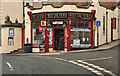
West End Stores
West End Stores in Richmond.
Image: © Peter McDermott
Taken: 19 Aug 2011
0.02 miles
9
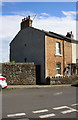
#17 Quaker Lane
The gable end of the house is pebbledashed
Image: © Roger Templeman
Taken: 22 Aug 2016
0.02 miles