IMAGES TAKEN NEAR TO
Morrison Industrial Estate, STANLEY, DH9 7XW
Introduction
This page details the photographs taken nearby to Morrison Industrial Estate, DH9 7XW by members of the Geograph project.
The Geograph project started in 2005 with the aim of publishing, organising and preserving representative images for every square kilometre of Great Britain, Ireland and the Isle of Man.

There are currently over 7.5m images from over14,400 individuals and you can help contribute to the project by visiting https://www.geograph.org.uk
Image Map
Images are licensed for reuse under creativecommons.org/licenses/by-sa/2.0
Notes
- Clicking on the map will re-center to the selected point.
- The higher the marker number, the further away the image location is from the centre of the postcode.
Image Listing (6 Images Found)
Images are licensed for reuse under creativecommons.org/licenses/by-sa/2.0
Image
Details
Distance
1
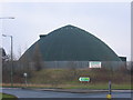
Salt Storage Container
View of a Salt Storage container used by Derwentside District Council. Situated near Annfield Plain on A693 heading towards Stanley.
Image: © Colin Edgar
Taken: 15 Jan 2006
0.06 miles
2
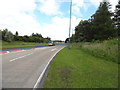
Annfield Plain bypass
Looking east long the bypass from the roundabout at the Morrison.
Image: © Robert Graham
Taken: 18 Jul 2012
0.09 miles
3
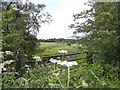
Looking across towards Annfield Plain
View across to Annfield Plain Park from the top of the path leading from Tower Road to the A6076 at the Morrison.
Image: © Robert Graham
Taken: 18 Jul 2012
0.17 miles
4

Overgrown footpath
This path leads north from Tower Road, across the reclaimed coal waste site to the A6076, near the site of the former Morrison Busty pit. A bit overgrown at the height of Summer.
Image: © Robert Graham
Taken: 18 Jul 2012
0.18 miles
5
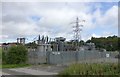
Annfield Electricity Substation
Between Annfield and Maiden Law.
Image: © Russel Wills
Taken: 4 Sep 2018
0.18 miles
6

Grazing horses
In a field beside Lanchester Road, the section of the A6076 leading into Annfield Plain from Maiden Law.
Image: © Robert Graham
Taken: 29 Sep 2020
0.25 miles