IMAGES TAKEN NEAR TO
Southfields, STANLEY, DH9 7PT
Introduction
This page details the photographs taken nearby to Southfields, DH9 7PT by members of the Geograph project.
The Geograph project started in 2005 with the aim of publishing, organising and preserving representative images for every square kilometre of Great Britain, Ireland and the Isle of Man.

There are currently over 7.5m images from over14,400 individuals and you can help contribute to the project by visiting https://www.geograph.org.uk
Image Map
Images are licensed for reuse under creativecommons.org/licenses/by-sa/2.0
Notes
- Clicking on the map will re-center to the selected point.
- The higher the marker number, the further away the image location is from the centre of the postcode.
Image Listing (13 Images Found)
Images are licensed for reuse under creativecommons.org/licenses/by-sa/2.0
Image
Details
Distance
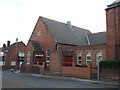
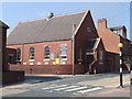
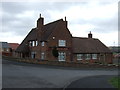
6
South Moor Police Station
Formerly, a police house.
Image: © Christine Johnstone
Taken: 14 Apr 2012
0.18 miles
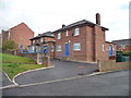
8
Not much in the way of back gardens
Bungalows in Maple Gardens backing onto South Moor Road.
Image: © Christine Johnstone
Taken: 14 Apr 2012
0.22 miles
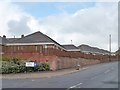
10
Derwent Rise, off South Moor Road
Derwent View is the latest development in this tangle of new streets and houses.
Image: © Christine Johnstone
Taken: 14 Apr 2012
0.23 miles