IMAGES TAKEN NEAR TO
STANLEY, DH9 7AZ
Introduction
This page details the photographs taken nearby to DH9 7AZ by members of the Geograph project.
The Geograph project started in 2005 with the aim of publishing, organising and preserving representative images for every square kilometre of Great Britain, Ireland and the Isle of Man.

There are currently over 7.5m images from over14,400 individuals and you can help contribute to the project by visiting https://www.geograph.org.uk
Image Map
Images are licensed for reuse under creativecommons.org/licenses/by-sa/2.0
Notes
- Clicking on the map will re-center to the selected point.
- The higher the marker number, the further away the image location is from the centre of the postcode.
Image Listing (17 Images Found)
Images are licensed for reuse under creativecommons.org/licenses/by-sa/2.0
Image
Details
Distance
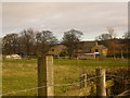
2
Farmhouse at Stanleyburn Farm, South Moor
This farm goes back to the early C19 at least. The present house and outbuildings are shown on the 1862 Ordnance Survey First Series map. The house hasn't been altered all that much and is a good example of a typical early C19 farmhouse. For almost the whole of the C20, the farm was held by the Oxley family and indeed was always known locally as "Oxley's Farm".
Image: © Robert Graham
Taken: 30 May 2014
0.01 miles
3
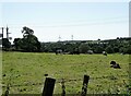
Cattle grazing at Stanleyburn Farm
This farm is in a rather urban setting on the edge of South Moor, but has continued to be a working farm.
Image: © Robert Graham
Taken: 16 Jul 2021
0.09 miles
4
Path leading to Stanleyburn Farm
This path leads from the west end of South Moor Park near Stanley to the farm and then on to South Moor.
Image: © Robert Graham
Taken: 18 Jul 2012
0.12 miles
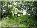
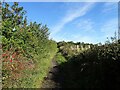
5
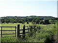
Footpath to Stanleyburn Farm
Stile for the path to this farm on the outskirts of South Moor. In the distance can be seen the former mining village of Quaking Houses.
Image: © Robert Graham
Taken: 16 Jul 2021
0.14 miles
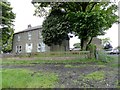
6
Public footpath to Quaking Houses
This path leads from Langley Terrace here down the bank to the village of Quaking Houses.
Image: © Robert Graham
Taken: 10 Jul 2018
0.14 miles
7
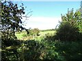
Footpath up to New Kyo
This path runs from the footpath down from Langley View, through the fields to the bypass. It looks rather overgrown at the moment.
Image: © Robert Graham
Taken: 29 Sep 2020
0.16 miles
8
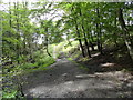
West end of South Moor Park
The path through the park ends at this flight of steps which leads out of the park. They have been recently repaired, part of extensive work carried out in the park.
Image: © Robert Graham
Taken: 18 Jul 2012
0.16 miles
9
Autumn hedgerow
Along the footpath leading up to New Kyo. Rosehips and crab apples in the trees on the left.
Image: © Robert Graham
Taken: 29 Sep 2020
0.17 miles
10
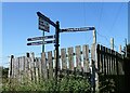
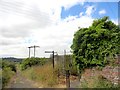
Footpath sign at Langley View
At the junction of two footpaths which link various old industrial sites, as can be seen from the names. There also appears to be an enterprising allotment holder here selling eggs.
Image: © Robert Graham
Taken: 16 Jul 2021
0.20 miles