IMAGES TAKEN NEAR TO
Poplar Street, STANLEY, DH9 7AY
Introduction
This page details the photographs taken nearby to Poplar Street, DH9 7AY by members of the Geograph project.
The Geograph project started in 2005 with the aim of publishing, organising and preserving representative images for every square kilometre of Great Britain, Ireland and the Isle of Man.

There are currently over 7.5m images from over14,400 individuals and you can help contribute to the project by visiting https://www.geograph.org.uk
Image Map
Images are licensed for reuse under creativecommons.org/licenses/by-sa/2.0
Notes
- Clicking on the map will re-center to the selected point.
- The higher the marker number, the further away the image location is from the centre of the postcode.
Image Listing (15 Images Found)
Images are licensed for reuse under creativecommons.org/licenses/by-sa/2.0
Image
Details
Distance
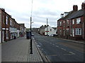
1
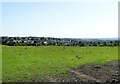
Terraced housing in South Moor
Long lines of chimneys of the terraced housing of South Moor are seen across a field north of Langley View.
Image: © Trevor Littlewood
Taken: 7 Mar 2014
0.03 miles
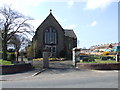
2
View over South Moor from the west
View from the path beside the A693 bypass. This is a good viewpoint at 230m (760ft) for a great view over the county.
Image: © Robert Graham
Taken: 16 Jul 2021
0.06 miles
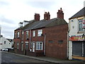
3
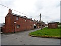
Ivy Terrace, South Moor
South Moor, a suburb of Stanley, was built mainly in the Edwardian period as long terraced streets for the miners. At the western end, this terrace of larger houses with large gardens was provided for the colliery officials. The first house was the colliery doctors, and the long building on the left hand side here contained stables for his pony and trap.
Image: © Robert Graham
Taken: 30 May 2014
0.08 miles
4
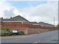
Not much in the way of back gardens
Bungalows in Maple Gardens backing onto South Moor Road.
Image: © Christine Johnstone
Taken: 14 Apr 2012
0.16 miles
5
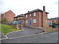
South Moor Police Station
Formerly, a police house.
Image: © Christine Johnstone
Taken: 14 Apr 2012
0.16 miles
6
Derwent Rise, off South Moor Road
Derwent View is the latest development in this tangle of new streets and houses.
Image: © Christine Johnstone
Taken: 14 Apr 2012
0.16 miles
7

East View, South Moor Road
More than a century must separate East and Derwent Views.
Image: © Christine Johnstone
Taken: 14 Apr 2012
0.17 miles