IMAGES TAKEN NEAR TO
Twizell Lane, STANLEY, DH9 6SH
Introduction
This page details the photographs taken nearby to Twizell Lane, DH9 6SH by members of the Geograph project.
The Geograph project started in 2005 with the aim of publishing, organising and preserving representative images for every square kilometre of Great Britain, Ireland and the Isle of Man.

There are currently over 7.5m images from over14,400 individuals and you can help contribute to the project by visiting https://www.geograph.org.uk
Image Map
Images are licensed for reuse under creativecommons.org/licenses/by-sa/2.0
Notes
- Clicking on the map will re-center to the selected point.
- The higher the marker number, the further away the image location is from the centre of the postcode.
Image Listing (16 Images Found)
Images are licensed for reuse under creativecommons.org/licenses/by-sa/2.0
Image
Details
Distance
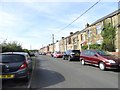
1
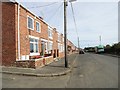
Looking down Twizell Lane
View down this long terrace of houses from the west end. It is in the ex mining village of West Pelton.
Image: © Robert Graham
Taken: 16 Sep 2019
0.01 miles
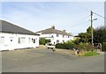
2
View down Twizell Lane from Eden Hill
At the SW end of West Pelton, looking down the long street of houses on the west side of Twizell Lane.
Image: © Robert Graham
Taken: 16 Sep 2019
0.03 miles
3
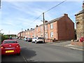
Brick terrace on Twizell Lane
At the west end of West Pelton is a long terrace of houses on Twizell Lane. It changes from stone to brick built half way along. All seem to have built in the early 20th century.
Image: © Robert Graham
Taken: 16 Sep 2019
0.03 miles
4
Terraced housing on Twizell Lane
Twizell Lane is in the small village of West Pelton.
Image: © Trevor Littlewood
Taken: 8 Mar 2017
0.04 miles
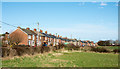
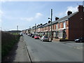
5
Long terraced row at West Pelton
This is Twizell Lane, which runs west from the village centre. These houses were built in the early 20th century, before the First World War, for the local miners.
Image: © Robert Graham
Taken: 16 Sep 2019
0.05 miles
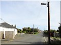
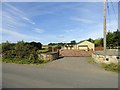
6
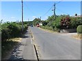
Twizell Lane and the entrance to Eden Hill Farm at West Pelton
Looking south-westward.
Image: © Peter Wood
Taken: 14 Jul 2018
0.10 miles
8
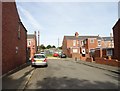
Plantation View, West Pelton
This is the street behind the long terrace of Twizell Lane. It consists of similar brick terraced miners houses from the early 20th century. Allotment gardens can be seen behind the houses. These were very typical of these mining villages.
Image: © Robert Graham
Taken: 16 Sep 2019
0.11 miles
9
Eden Hill Farm, West Pelton
This is just past the SW end of the long street of houses on Twizell Lane. The farmhouse, on the right here, appears to be the original one shown on the 1861 O S First Series map. The layout suggests it is an early Victorian planned courtyard type. It was here before the mining village of West Pelton came into existence in the later 19th century.
Image: © Robert Graham
Taken: 16 Sep 2019
0.13 miles
10
Stables at Eden Hill Farm
On Twizell Lane in West Pelton. Although the farm dates back to Victorian times, these smart stables are obviously new.
Image: © Robert Graham
Taken: 16 Sep 2019
0.14 miles