IMAGES TAKEN NEAR TO
Wylam Street, STANLEY, DH9 6ER
Introduction
This page details the photographs taken nearby to Wylam Street, DH9 6ER by members of the Geograph project.
The Geograph project started in 2005 with the aim of publishing, organising and preserving representative images for every square kilometre of Great Britain, Ireland and the Isle of Man.

There are currently over 7.5m images from over14,400 individuals and you can help contribute to the project by visiting https://www.geograph.org.uk
Image Map
Images are licensed for reuse under creativecommons.org/licenses/by-sa/2.0
Notes
- Clicking on the map will re-center to the selected point.
- The higher the marker number, the further away the image location is from the centre of the postcode.
Image Listing (28 Images Found)
Images are licensed for reuse under creativecommons.org/licenses/by-sa/2.0
Image
Details
Distance
1
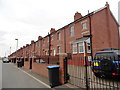
Wylam Street, Craghead
This old terraced street has been revitalised in recent years.
Image: © Robert Graham
Taken: 30 May 2014
0.02 miles
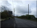
4
Long terraced street at Craghead
This is Railway Street, a typical long row of ex miners terraced houses built in the late C19. They appear to have been modernised recently.
Image: © Robert Graham
Taken: 9 Sep 2019
0.07 miles
6
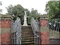
War Memorial, Craghead
Beside Edward Street, in a little park. As is usual, it commemorates both World Wars.
Image: © Robert Graham
Taken: 9 Sep 2019
0.08 miles
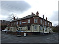
7
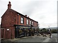
The Punch Bowl, Craghead
This pub in the centre of the village dates from the late 19th century when most of the present village was built for local miners. It still appears to be thriving, and hasn't changed its name, rather unusually.
Image: © Robert Graham
Taken: 9 Sep 2019
0.10 miles
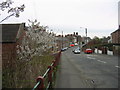
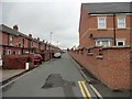
10
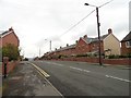
View along Edward Street in Craghead
Looking north along the main street through the village. Craghead was mainly built in the late 19th century for local miners. The terraces here date from this period.
Image: © Robert Graham
Taken: 9 Sep 2019
0.11 miles