IMAGES TAKEN NEAR TO
Ousterley Terrace, STANLEY, DH9 6EF
Introduction
This page details the photographs taken nearby to Ousterley Terrace, DH9 6EF by members of the Geograph project.
The Geograph project started in 2005 with the aim of publishing, organising and preserving representative images for every square kilometre of Great Britain, Ireland and the Isle of Man.

There are currently over 7.5m images from over14,400 individuals and you can help contribute to the project by visiting https://www.geograph.org.uk
Image Map
Images are licensed for reuse under creativecommons.org/licenses/by-sa/2.0
Notes
- Clicking on the map will re-center to the selected point.
- The higher the marker number, the further away the image location is from the centre of the postcode.
Image Listing (26 Images Found)
Images are licensed for reuse under creativecommons.org/licenses/by-sa/2.0
Image
Details
Distance
1
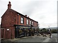
The Punch Bowl, Craghead
This pub in the centre of the village dates from the late 19th century when most of the present village was built for local miners. It still appears to be thriving, and hasn't changed its name, rather unusually.
Image: © Robert Graham
Taken: 9 Sep 2019
0.00 miles
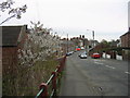
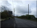
4
Village crossroads, Craghead
The ex mining village of Craghead was created around this crossroad, mainly in the late 19th century. View is looking south up Durham Road to the crossroads. The village main street is to the left, and Wagtail lane to the right.
Image: © Robert Graham
Taken: 9 Sep 2019
0.01 miles
6
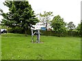
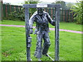
Miners sculpture in Craghead
This stands next to the crossroads in the centre of the village where Durham Road and Craghead Lane meet. It is one of several artworks erected in the village in recent years on the initiative of the local people.
Image: © Robert Graham
Taken: 30 May 2014
0.03 miles
7
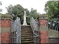
War Memorial, Craghead
Beside Edward Street, in a little park. As is usual, it commemorates both World Wars.
Image: © Robert Graham
Taken: 9 Sep 2019
0.04 miles
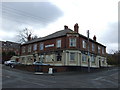
8
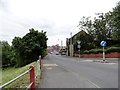
Looking down to Front Street, Craghead
This is a view from the crossroads in the centre of the village. The large stone building in the centre was formerly the Craghead Hotel and dates from Victorian times.
Image: © Robert Graham
Taken: 30 May 2014
0.05 miles
10
Sculpture of miner Craghead near Stanley
Image: © P Glenwright
Taken: 23 Sep 2006
0.06 miles