IMAGES TAKEN NEAR TO
Craghead, STANLEY, DH9 6DU
Introduction
This page details the photographs taken nearby to DH9 6DU by members of the Geograph project.
The Geograph project started in 2005 with the aim of publishing, organising and preserving representative images for every square kilometre of Great Britain, Ireland and the Isle of Man.

There are currently over 7.5m images from over14,400 individuals and you can help contribute to the project by visiting https://www.geograph.org.uk
Image Map
Images are licensed for reuse under creativecommons.org/licenses/by-sa/2.0
Notes
- Clicking on the map will re-center to the selected point.
- The higher the marker number, the further away the image location is from the centre of the postcode.
Image Listing (25 Images Found)
Images are licensed for reuse under creativecommons.org/licenses/by-sa/2.0
Image
Details
Distance
2
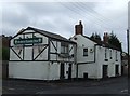
John's Castle Inn, Craghead
This pub on Craghead Lane, the main street through the village, dates back to the late 19th century. It is listed in a directory of 1894, along with two others. Rather surprisingly for most villages, two of these are still open, including this one.
Image: © Robert Graham
Taken: 12 Aug 2019
0.05 miles
3
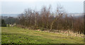
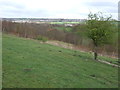
Birch trees beyond paddock
The enclosure, too small to call a field, lies on the north side of the B6313 Craghead Lane in the old County Durham 'pit village' of Craghead. The ground beyond falls away to the valley of the Twizell Burn.
Image: © Trevor Littlewood
Taken: 15 Feb 2017
0.10 miles
4
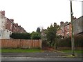
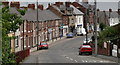
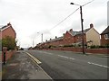
Terraced streets in Craghead
Formers miners houses built in the late 19th century. These are Surtees and Lampton Terraces, very typical of Co Durham mining villages.
Image: © Robert Graham
Taken: 9 Sep 2019
0.11 miles
5
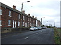
Craghead, County Durham
Craghead is an old 'pit village' of County Durham; here the B6313 heads E. on its N. side.
Image: © Trevor Littlewood
Taken: 14 Jul 2010
0.12 miles
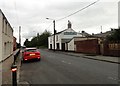
7
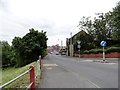
Looking down to Front Street, Craghead
This is a view from the crossroads in the centre of the village. The large stone building in the centre was formerly the Craghead Hotel and dates from Victorian times.
Image: © Robert Graham
Taken: 30 May 2014
0.15 miles
8
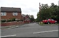
Entrance to George Street, Craghead
This street runs behind Edward Street, the main street through the south side of the village. It is another of the late 19th century terraced streets in this ex mining village.
Image: © Robert Graham
Taken: 9 Sep 2019
0.17 miles
10
View along Edward Street in Craghead
Looking north along the main street through the village. Craghead was mainly built in the late 19th century for local miners. The terraces here date from this period.
Image: © Robert Graham
Taken: 9 Sep 2019
0.17 miles