IMAGES TAKEN NEAR TO
Craghead, STANLEY, DH9 6DN
Introduction
This page details the photographs taken nearby to DH9 6DN by members of the Geograph project.
The Geograph project started in 2005 with the aim of publishing, organising and preserving representative images for every square kilometre of Great Britain, Ireland and the Isle of Man.

There are currently over 7.5m images from over14,400 individuals and you can help contribute to the project by visiting https://www.geograph.org.uk
Image Map
Images are licensed for reuse under creativecommons.org/licenses/by-sa/2.0
Notes
- Clicking on the map will re-center to the selected point.
- The higher the marker number, the further away the image location is from the centre of the postcode.
Image Listing (27 Images Found)
Images are licensed for reuse under creativecommons.org/licenses/by-sa/2.0
Image
Details
Distance
1
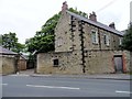
Shafto House, Craghead
This fine old house is one of the oldest surviving houses in the village. It is shown on the first Ordnance Survey map of 1861 and in 1838 it is recorded as being the residence of William Hedley. He was an famous mining engineer and railway pioneer. He moved from here to a much grander house at Burnopside Hall near Lanchester, where he died in 1843.
Image: © Robert Graham
Taken: 30 May 2014
0.01 miles
2
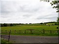
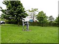
View towards Ousterley
Looking southwest from Middles Road, Craghead. The farm in the distance is Ousterley Farm, and the houses are on Wagtail Lane.
Image: © Robert Graham
Taken: 30 May 2014
0.08 miles
3
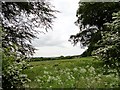
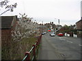
View east from Middles Road, Craghead
This stretch of farmland separates the Middles area of Craghead from the older part of the village to the south. A nice display of roadside spring blossom also.
Image: © Robert Graham
Taken: 30 May 2014
0.09 miles
4
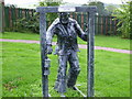
Sculpture of miner Craghead near Stanley
Image: © P Glenwright
Taken: 23 Sep 2006
0.10 miles
6
Miners sculpture in Craghead
This stands next to the crossroads in the centre of the village where Durham Road and Craghead Lane meet. It is one of several artworks erected in the village in recent years on the initiative of the local people.
Image: © Robert Graham
Taken: 30 May 2014
0.10 miles
7
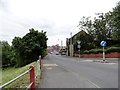
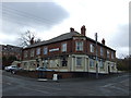
Looking down to Front Street, Craghead
This is a view from the crossroads in the centre of the village. The large stone building in the centre was formerly the Craghead Hotel and dates from Victorian times.
Image: © Robert Graham
Taken: 30 May 2014
0.12 miles
8
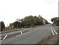
Village crossroads, Craghead
The ex mining village of Craghead was created around this crossroad, mainly in the late 19th century. View is looking south up Durham Road to the crossroads. The village main street is to the left, and Wagtail lane to the right.
Image: © Robert Graham
Taken: 9 Sep 2019
0.12 miles