IMAGES TAKEN NEAR TO
Standerton Terrace, STANLEY, DH9 6DD
Introduction
This page details the photographs taken nearby to Standerton Terrace, DH9 6DD by members of the Geograph project.
The Geograph project started in 2005 with the aim of publishing, organising and preserving representative images for every square kilometre of Great Britain, Ireland and the Isle of Man.

There are currently over 7.5m images from over14,400 individuals and you can help contribute to the project by visiting https://www.geograph.org.uk
Image Map
Images are licensed for reuse under creativecommons.org/licenses/by-sa/2.0
Notes
- Clicking on the map will re-center to the selected point.
- The higher the marker number, the further away the image location is from the centre of the postcode.
Image Listing (10 Images Found)
Images are licensed for reuse under creativecommons.org/licenses/by-sa/2.0
Image
Details
Distance
1
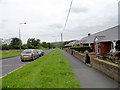
Aged Miners' Homes at Craghead
These retirement bungalows on Durham Road were built in 1923, and are typical of many in this area of County Durham.
Image: © Robert Graham
Taken: 30 May 2014
0.13 miles
3
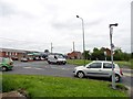
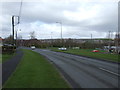
Village crossroads in Craghead
Junction of Durham Road and Middles Road. Although this part of the village is called The Middles on the map, it's known locally as "The Font". This is an abbreviation of Bloemfontein - all the old streets here were named after battles in the Boer War.
Image: © Robert Graham
Taken: 30 May 2014
0.13 miles
4
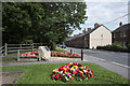
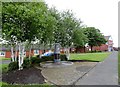
Middles Road with military memorial
The Middles is a small County Durham village between Stanley and Craghead. The memorial is to Private Michael Heaviside who was awarded the Victoria Cross for his actions of 6 May 1917 resulting in the rescue, under fire, of a wounded soldier from no man's land.
Image: © Trevor Littlewood
Taken: 2 Aug 2021
0.13 miles
6
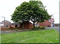
Miner's Lamp at Craghead
This artwork stands on Middles Road at the eastern end of the village. It represents a miner's safety lamp and commemorates the mining past of the village.
Image: © Robert Graham
Taken: 30 May 2014
0.17 miles
8
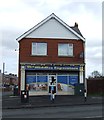
Bloemfontein Place, Craghead
The streets in this part of Craghead were built in the early C20, and took their names from the recently ended Boer War. Bloemfontein was the capital of the Boer republic of the Orange Free State and was captured by the British. The area here was locally known by the more practical name of "The Font".
Image: © Robert Graham
Taken: 30 May 2014
0.19 miles
9

Terraced streets in Craghead
Typical of many streets of terraced housing in the former mining village of Craghead. This is Chaytor Terrace, in the area known as The Middles, but more locally as Chinatown.
Image: © Robert Graham
Taken: 30 May 2014
0.23 miles
10
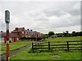
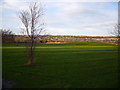
Footpath along Chaytor Terrace, Craghead
This public path leads along the terraced street and into Stanley Wood.
Image: © Robert Graham
Taken: 30 May 2014
0.25 miles