IMAGES TAKEN NEAR TO
Beamish, STANLEY, DH9 0RJ
Introduction
This page details the photographs taken nearby to DH9 0RJ by members of the Geograph project.
The Geograph project started in 2005 with the aim of publishing, organising and preserving representative images for every square kilometre of Great Britain, Ireland and the Isle of Man.

There are currently over 7.5m images from over14,400 individuals and you can help contribute to the project by visiting https://www.geograph.org.uk
Image Map
Images are licensed for reuse under creativecommons.org/licenses/by-sa/2.0
Notes
- Clicking on the map will re-center to the selected point.
- The higher the marker number, the further away the image location is from the centre of the postcode.
Image Listing (13 Images Found)
Images are licensed for reuse under creativecommons.org/licenses/by-sa/2.0
Image
Details
Distance
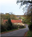
1
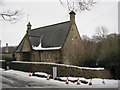
Cottage near Beamish Hall
This may have been a lodge house for Beamish Hall.
Image: © Les Hull
Taken: 12 Jan 2010
0.02 miles
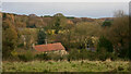
2
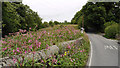
Field adjacent to minor road
The road is rising northwards from a bridge over the Beamish Burn just north of Stanley. The pink flowers are those of Himalayan balsam, an introduced species, highly invasive and now naturalised.
Image: © Trevor Littlewood
Taken: 23 Aug 2013
0.02 miles
3
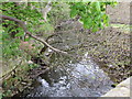
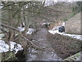
Beamish Burn
Looking east down onto the burn from Beamish Burn Bridge.
Image: © Peter Wood
Taken: 10 May 2013
0.02 miles
4
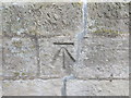
Ordnance Survey Cut Mark
This mark can be found on Beamish Burn Bridge.
For more detail see : http://www.bench-marks.org.uk/bm48494
Image: © Peter Wood
Taken: 10 May 2013
0.02 miles

8
Beamish Burn Bridge
The 'Grey Lady' of Beamish Hall is said to appear near Beamish Burn after suffocating in a trunk where she hid to avoid an unwanted arranged marriage.
Image: © Alan Fearon
Taken: 10 Nov 2005
0.08 miles
9
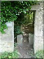
Entrance to Carrickshill Wood
Not the only way into this plot of woodland managed by Durham County Council.
Image: © Oliver Dixon
Taken: 16 Jul 2021
0.11 miles
