IMAGES TAKEN NEAR TO
Beamish, STANLEY, DH9 0QS
Introduction
This page details the photographs taken nearby to DH9 0QS by members of the Geograph project.
The Geograph project started in 2005 with the aim of publishing, organising and preserving representative images for every square kilometre of Great Britain, Ireland and the Isle of Man.

There are currently over 7.5m images from over14,400 individuals and you can help contribute to the project by visiting https://www.geograph.org.uk
Image Map
Images are licensed for reuse under creativecommons.org/licenses/by-sa/2.0
Notes
- Clicking on the map will re-center to the selected point.
- The higher the marker number, the further away the image location is from the centre of the postcode.
Image Listing (11 Images Found)
Images are licensed for reuse under creativecommons.org/licenses/by-sa/2.0
Image
Details
Distance
1
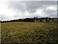
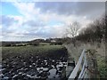
Park Nook Farm
In the fields between Beamish and East Stanley. Pictured from the footpath leading up from the old railway walk.
Image: © Robert Graham
Taken: 6 Feb 2013
0.01 miles
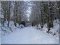
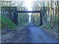
3
Bridge over Consett and Sunderland Railway Trail
Image: © Les Hull
Taken: 5 Jan 2010
0.11 miles
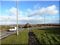
4
Junction on A693
Where the road from No Place joins it.
Looking down across the Team Valley.
Image: © Russel Wills
Taken: 4 Sep 2016
0.12 miles
5
Consett and Sunderland Railway Path at Beamish
This railway path forms part of the famous C2C cycle route. Here a footpath crosses the trail by a footbridge.
Image: © Oliver Dixon
Taken: 8 Jan 2014
0.13 miles
6
View east from Hilltop
This spot at the far east end of Stanley is well named. At about 700 feet, it gives superb views of the surrounding area. Picture taken by the side of the main road, the A693.
Image: © Robert Graham
Taken: 6 Feb 2013
0.15 miles
7
No Place ... Like a Co-operative Home!
Image: © Terry Robinson
Taken: 9 Oct 2008
0.17 miles
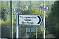
8
Junction on the A693
To No Place (Cooperative Villas).
The origins of the village's unusual name are uncertain; however, theories include a shortening of "North Place", "Near Place" or "Nigh Place".
Derwentside Council tried to change the name of the village to Co-operative Villas in 1983; however, they met with strong protests from local residents at the removal of all signs pointing to No Place. Today the signs say both No Place and (at the request of some residents) Co-operative Villas.
Image: © Russel Wills
Taken: 4 Sep 2016
0.18 miles
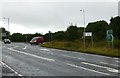
9
View east from Park Nook
West of Beamish. The fields are very clarty (to use a good old Northeast expression) after a very wet few months. The village of No Place can be seen in the centre. Of uncertain origin, the peculiar name is obviously popular with the villagers, who resisted a council attempt to change it in the sixties.
Image: © Robert Graham
Taken: 6 Feb 2013
0.18 miles
