IMAGES TAKEN NEAR TO
Benton Terrace, STANLEY, DH9 0NT
Introduction
This page details the photographs taken nearby to Benton Terrace, DH9 0NT by members of the Geograph project.
The Geograph project started in 2005 with the aim of publishing, organising and preserving representative images for every square kilometre of Great Britain, Ireland and the Isle of Man.

There are currently over 7.5m images from over14,400 individuals and you can help contribute to the project by visiting https://www.geograph.org.uk
Image Map
Images are licensed for reuse under creativecommons.org/licenses/by-sa/2.0
Notes
- Clicking on the map will re-center to the selected point.
- The higher the marker number, the further away the image location is from the centre of the postcode.
Image Listing (43 Images Found)
Images are licensed for reuse under creativecommons.org/licenses/by-sa/2.0
Image
Details
Distance
1
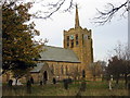
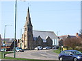
St.Andrew's Church, Stanley, Co. Durham
For a tragic story associated with the church see:
http://www.thisisthenortheast.co.uk/the_north_east/news/campaigns/memorial/pages/160202_1.html
Image: © Alan Fearon
Taken: 10 Oct 2005
0.03 miles
2
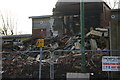
Elite Buildings Stanley
After the in sept 2013
Image: © ROBERT RAFFERTY
Taken: 15 Dec 2013
0.04 miles
3

Elite Buildings Stanley
After the fire in sept 2013.
Image: © ROBERT RAFFERTY
Taken: 15 Dec 2013
0.04 miles
4

The Royal Hotel, Front Street, Stanley
A public house at the northern end of Front Street. The lane to the left of the pub is named Royal Road, likely after the pub.
Image: © Graham Robson
Taken: 28 Oct 2018
0.05 miles
6
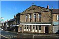
Hibernian Hall, Station Road, Stanley
The disused building, dating from 1907, was formerly a Working Men's Club.
Image: © Graham Robson
Taken: 28 Oct 2018
0.06 miles
7

St Joseph's Primary School, Front Street, Stanley
St Joseph's Catholic Primary School, located at the northern end of Front Street in the middle of Stanley.
Image: © Graham Robson
Taken: 28 Oct 2018
0.06 miles
8
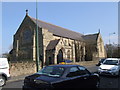
Christ Church United Reformed Church, Stanley
Image: © Peter Gregson
Taken: 7 Apr 2007
0.06 miles
9
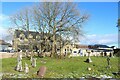
Churchyard of St Joseph's Church, Stanley
The grassy churchyard beside the Catholic St Joseph's Church in the middle of Stanley. Behind the fence on the other side of the churchyard is St Joseph's Catholic Primary School.
Image: © Graham Robson
Taken: 28 Oct 2018
0.06 miles
10
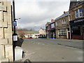
Station Road at Stanley
This is a view from the top of Station Road which leads down to Shield Row, where the actual station used to be.
Image: © Robert Graham
Taken: 9 Mar 2012
0.07 miles