IMAGES TAKEN NEAR TO
STANLEY, DH9 0LS
Introduction
This page details the photographs taken nearby to DH9 0LS by members of the Geograph project.
The Geograph project started in 2005 with the aim of publishing, organising and preserving representative images for every square kilometre of Great Britain, Ireland and the Isle of Man.

There are currently over 7.5m images from over14,400 individuals and you can help contribute to the project by visiting https://www.geograph.org.uk
Image Map
Images are licensed for reuse under creativecommons.org/licenses/by-sa/2.0
Notes
- Clicking on the map will re-center to the selected point.
- The higher the marker number, the further away the image location is from the centre of the postcode.
Image Listing (10 Images Found)
Images are licensed for reuse under creativecommons.org/licenses/by-sa/2.0
Image
Details
Distance
2
South Causey Inn
One of several licensed premises on Beamishburn Road.
Image: © Oliver Dixon
Taken: 8 Jan 2014
0.09 miles
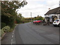
3
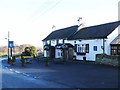
The Blue Bell Inn
One of several licensed premises on Beamishburn Road.
Image: © Oliver Dixon
Taken: 8 Jan 2014
0.10 miles
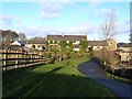
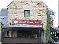
4
South Causey Inn
Refurbished in recent years (see: http://www.geograph.org.uk/photo/76501 ). Excellent food.
Image: © Pete Saunders
Taken: 29 Jun 2008
0.10 miles
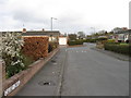
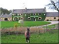
6
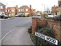
Beamishburn Road near the Blue Bell Inn at South Causey
Looking north-eastward.
Image: © Peter Wood
Taken: 6 Oct 2018
0.11 miles
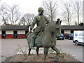
7
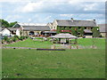
South Causey Hotel
This hotel is part of a farm and an Equestrian Centre.
Image: © Alan Fearon
Taken: 10 Nov 2005
0.14 miles
9
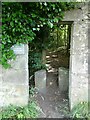
Entrance to Carrickshill Wood
Not the only way into this plot of woodland managed by Durham County Council.
Image: © Oliver Dixon
Taken: 16 Jul 2021
0.23 miles