IMAGES TAKEN NEAR TO
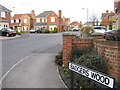
Badgers Wood, STANLEY, DH9 0HR
Introduction
This page details the photographs taken nearby to Badgers Wood, DH9 0HR by members of the Geograph project.
The Geograph project started in 2005 with the aim of publishing, organising and preserving representative images for every square kilometre of Great Britain, Ireland and the Isle of Man.

There are currently over 7.5m images from over14,400 individuals and you can help contribute to the project by visiting https://www.geograph.org.uk
Image Map
Images are licensed for reuse under creativecommons.org/licenses/by-sa/2.0
Notes
- Clicking on the map will re-center to the selected point.
- The higher the marker number, the further away the image location is from the centre of the postcode.
Image Listing (15 Images Found)
Images are licensed for reuse under creativecommons.org/licenses/by-sa/2.0
Image
Details
Distance
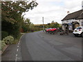
3
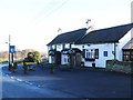
The Blue Bell Inn
One of several licensed premises on Beamishburn Road.
Image: © Oliver Dixon
Taken: 8 Jan 2014
0.08 miles
5
Beamishburn Road near the Blue Bell Inn at South Causey
Looking north-eastward.
Image: © Peter Wood
Taken: 6 Oct 2018
0.10 miles
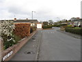
6
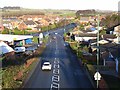
Pelaw Avenue, Stanley
Seen from a bridge on the Consett and Sunderland Railway Path. At the foot of the hill, Pelaw Avenue joins the A6076.
Image: © Oliver Dixon
Taken: 8 Jan 2014
0.10 miles
8
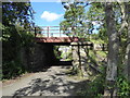
Old railway bridge, Shield Row
This bridge once carried the Birtley, Annfield Plain and Consett railway but today is only used by walkers, cyclists and horse riders on the Consett and Sunderland Railway Path.
The public footpath under the bridge runs from Beamish South Moor to Kip Hill.
Image: © Adrian Taylor
Taken: 20 Aug 2020
0.16 miles
9
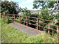
Railway bridge railings, Shield Row
The original railings survive almost intact, but have been supplemented by additional end railings of different designs for safety when the Consett to Sunderland Railway Path was created after the railway closed.
A public footpath from Beamish South Moor to Kip Hill passes under the bridge.
Image: © Adrian Taylor
Taken: 20 Aug 2020
0.16 miles
10
South Causey Inn
One of several licensed premises on Beamishburn Road.
Image: © Oliver Dixon
Taken: 8 Jan 2014
0.19 miles