IMAGES TAKEN NEAR TO
Wylam Road, STANLEY, DH9 0EE
Introduction
This page details the photographs taken nearby to Wylam Road, DH9 0EE by members of the Geograph project.
The Geograph project started in 2005 with the aim of publishing, organising and preserving representative images for every square kilometre of Great Britain, Ireland and the Isle of Man.

There are currently over 7.5m images from over14,400 individuals and you can help contribute to the project by visiting https://www.geograph.org.uk
Image Map
Images are licensed for reuse under creativecommons.org/licenses/by-sa/2.0
Notes
- Clicking on the map will re-center to the selected point.
- The higher the marker number, the further away the image location is from the centre of the postcode.
Image Listing (12 Images Found)
Images are licensed for reuse under creativecommons.org/licenses/by-sa/2.0
Image
Details
Distance
1
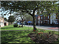
Small public garden at Shield Row
The garden is beside the A6076, Station Road. Shield Row is part of the County Durham town of Stanley; the yellow and blue road sign naming the district is in a style introduced in the County some years ago.
Image: © Trevor Littlewood
Taken: 2 Sep 2014
0.08 miles

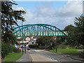
4
Bridge on the Consett and Sunderland Path at Stanley
Part of National Cycle Network route 7, and the famous C2C Cycle Route. Here crossing a striking modern bridge over the A6076 which runs from Stanley to Sunniside.
Image: © Oliver Dixon
Taken: 8 Jan 2014
0.19 miles
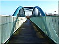
5
Bridge carrying railway path
This bridge on the N. side of the County Durham town of Stanley now carries the Consett & Sunderland Railway Path. The structure replaced the original railway bridge.
Image: © Trevor Littlewood
Taken: 15 Sep 2010
0.19 miles

7
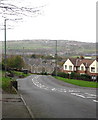
Shield Row, Co.Durham
Looking north west down Pelaw Ave, East Stanley to the left and Beamish South Moor to the right
Image: © Alan Fearon
Taken: 10 Nov 2005
0.20 miles


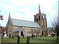
10
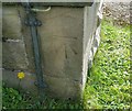
Ordnance Survey Cut Mark
This OS cut mark can be found on the NW angle of St Andrew's Church. It marks a point 218.080m above mean sea level.
Image: © Adrian Dust
Taken: 16 Sep 2018
0.23 miles