IMAGES TAKEN NEAR TO
Clifford Road, STANLEY, DH9 0AB
Introduction
This page details the photographs taken nearby to Clifford Road, DH9 0AB by members of the Geograph project.
The Geograph project started in 2005 with the aim of publishing, organising and preserving representative images for every square kilometre of Great Britain, Ireland and the Isle of Man.

There are currently over 7.5m images from over14,400 individuals and you can help contribute to the project by visiting https://www.geograph.org.uk
Image Map
Images are licensed for reuse under creativecommons.org/licenses/by-sa/2.0
Notes
- Clicking on the map will re-center to the selected point.
- The higher the marker number, the further away the image location is from the centre of the postcode.
Image Listing (51 Images Found)
Images are licensed for reuse under creativecommons.org/licenses/by-sa/2.0
Image
Details
Distance
1
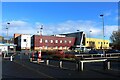
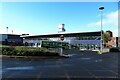
Stanley Primary Care Centre
A modern building housing healthcare facilities in the centre of Stanley.
Image: © Graham Robson
Taken: 28 Oct 2018
0.03 miles
2
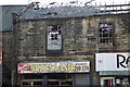
Pizza land front street stanley
Taken after the fire 15/12/2013
Image: © ROBERT RAFFERTY
Taken: 15 Dec 2013
0.04 miles
3
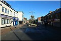
Front Street, Stanley
Looking along the pedestrianised town centre street on a quiet autumnal Sunday morning.
Image: © Graham Robson
Taken: 28 Oct 2018
0.04 miles
4
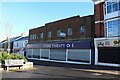
Former Store Twenty One, Stanley
The Store Twenty One business collapsed in 2017, a year before this photo was taken, leaving this large shop in the centre of Stanley unoccupied.
Image: © Graham Robson
Taken: 28 Oct 2018
0.05 miles
5

Poundstretcher store, Front Street, Stanley
A branch of the large Poundstretcher retail business located on Front Street in Stanley.
Image: © Graham Robson
Taken: 28 Oct 2018
0.06 miles
6
Stanley Bus Station
The town's bus station, located close to the main shopping street in Stanley and served predominately by buses operated by Go North East.
Image: © Graham Robson
Taken: 28 Oct 2018
0.07 miles
7
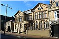
Former council offices, Front Street, Stanley
The former town centre administrative base for the local authority, located on Front Street. The building is now grade ii listed, https://historicengland.org.uk/listing/the-list/list-entry/1260825
Image: © Graham Robson
Taken: 28 Oct 2018
0.07 miles
8
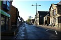
Front Street, Stanley
Looking south down Front Street in Stanley early on a wet Sunday morning in late October.
Image: © Graham Robson
Taken: 28 Oct 2018
0.07 miles
9
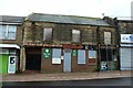
Former Berties Bar, Front Street, Stanley
Five years after a fire in 2013 Image Berties Bar was still awaiting redevelopment.
Image: © Graham Robson
Taken: 28 Oct 2018
0.08 miles
10
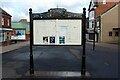
Notice board in Stanley town centre
A notice board in the heart of Stanley. The top of the board is decorated with scenes of local signifigance.
Image: © Graham Robson
Taken: 28 Oct 2018
0.08 miles