IMAGES TAKEN NEAR TO
Shotley Bridge, CONSETT, DH8 9TF
Introduction
This page details the photographs taken nearby to DH8 9TF by members of the Geograph project.
The Geograph project started in 2005 with the aim of publishing, organising and preserving representative images for every square kilometre of Great Britain, Ireland and the Isle of Man.

There are currently over 7.5m images from over14,400 individuals and you can help contribute to the project by visiting https://www.geograph.org.uk
Image Map (Loading...)


Getting Data...Please wait
Leaflet Map data © OpenStreetMap
Images are licensed for reuse under creativecommons.org/licenses/by-sa/2.0
Notes
- Clicking on the map will re-center to the selected point.
- The higher the marker number, the further away the image location is from the centre of the postcode.
Image Listing (12 Images Found)
Images are licensed for reuse under creativecommons.org/licenses/by-sa/2.0
Image
Details
Distance
1
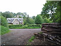
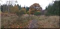
Burn House, near Shotley Bridge
This is a former gamekeeper's cottage on the Shotley Hall estate, built in 1860. Reached down a track off the B6278, it's a real "cottage in the woods".
Image: © Robert Graham
Taken: 9 Jun 2011
0.01 miles
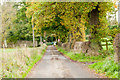
2
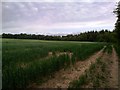
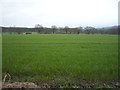
Fields beside Hall Wood
Looking North from the edge of Hall Wood to Burnhouse Gill. Fields look parched due to the very dry Spring this year.
Image: © Robert Graham
Taken: 9 Jun 2011
0.08 miles
3
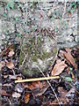
Old Milestone by the B6278, Burnmill Bank, Shotley
Carved stone post by the B6278, Parish of Shotley Low Quarter, Tynedale District; Shotley Hall, Shotley Bridge, against wall on verge, South side of road. 19th century, erected by the Lobley Hill & Burtreeford Turnpike Trust.
Inscription once read:- : (Stanhope 12) : : (Gateshead 14) :
Milestone Society National ID: NB_SHGH12.
Image: © Milestone Society
Taken: 9 Dec 2017
0.14 miles
4
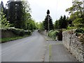
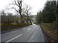
View along Burnmill Bank, Shotley Bridge
This road leads west from the bridge over the Derwent into Northumberland.
Image: © Robert Graham
Taken: 22 May 2015
0.15 miles
8
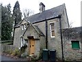
Waskerley Lodge, Shotley Bridge
This cottage stands at the top of the lane leading to the farming hamlet of Low Waskerley and was once the entrance lodge for the estate, to judge by its name. There is a date of 1860 on the plaque above the door.
Image: © Robert Graham
Taken: 17 Dec 2014
0.19 miles
9

Date plaque at Waskerley Lodge
The lodge takes its name from Low Waskerley farm further along the lane. This was a big Victorian farmstead, and presumably merited a lodge here at the end of the lane. In my experience, it is most unusual to see any sort of date inscription on a secular building in this area.
Image: © Robert Graham
Taken: 21 Sep 2020
0.20 miles
10
Minor road heading towards B6278
The B6278 lies just beyond the 30 mph speed limit signs. A left turn there takes one very soon over the River Derwent, out of Northumberland and into Shotley Bridge in County Durham.
Image: © Trevor Littlewood
Taken: 14 Nov 2015
0.22 miles