IMAGES TAKEN NEAR TO
Shotley Bridge, CONSETT, DH8 9TE
Introduction
This page details the photographs taken nearby to DH8 9TE by members of the Geograph project.
The Geograph project started in 2005 with the aim of publishing, organising and preserving representative images for every square kilometre of Great Britain, Ireland and the Isle of Man.

There are currently over 7.5m images from over14,400 individuals and you can help contribute to the project by visiting https://www.geograph.org.uk
Image Map
Images are licensed for reuse under creativecommons.org/licenses/by-sa/2.0
Notes
- Clicking on the map will re-center to the selected point.
- The higher the marker number, the further away the image location is from the centre of the postcode.
Image Listing (68 Images Found)
Images are licensed for reuse under creativecommons.org/licenses/by-sa/2.0
Image
Details
Distance
1
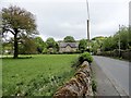
Looking east down Burnmill Bank, Shotley Bridge
View down the bottom of the bank leading down to the River Derwent.
Image: © Robert Graham
Taken: 22 May 2015
0.03 miles
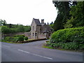
2
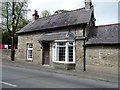
Shotley Bridge
The cottage was formerly a toll house on the turnpike now known as the B6278.
Image: © Gordon Fenwick
Taken: 15 Nov 2006
0.03 miles
3
House on Burnmill Bank, Shotley Bridge
Located near the bottom of the bank, a short distance west of the bridge over the Derwent. Noticeable in having a date marked on the gable in inset bricks. In my experience, date markings of any kind are rare on secular buildings in this area.
Image: © Robert Graham
Taken: 22 May 2015
0.03 miles
4
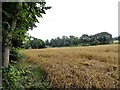
Field at Shotley Bridge
This field of ripe oats is next to the river. View is looking towards the houses on Burnmill Bank.
Image: © Robert Graham
Taken: 19 Aug 2019
0.03 miles
5
Cottage on Burnmill Bank, Shotley Bridge
This nice little house has the name "Gate House" and a date of 1903 either side of the door. Dates on houses are rare in this part of the world, in my experience, so nice to see this one.
Image: © Robert Graham
Taken: 22 May 2015
0.04 miles
6
Cottage on Burnmill Bank, Shotley Bridge
This is a view along the B6278 leading out of the village to the west. It leads to the A68 at Caterway Heads. The cottage is called The Gatehouse.
Image: © Robert Graham
Taken: 21 Sep 2020
0.04 miles
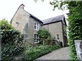
7
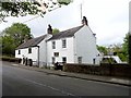
Orchard House, Shotley Bridge
One of the most interesting houses in the village, located at the bottom of Burnmill Bank. This was formerly an inn, with the left hand block dating to the mid C18, and the set back right hand block a C19 addition.
Image: © Robert Graham
Taken: 22 May 2015
0.04 miles
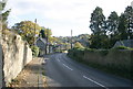
8
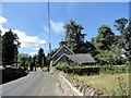
Burnmill Bank at Shotley Bridge
This is the B6278 which leads west out of the village to the A68 at Caterway Heads.
Image: © Robert Graham
Taken: 6 Jul 2018
0.04 miles
9
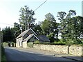
Gate Lodge to Shotley Hall
On the B6278 leading West out of Shotley Bridge, this dates to 1856 by Thomas Wilson. Described elsewhere as in "playful Gothic style", and you couldn't disagree with that.
Image: © Robert Graham
Taken: 9 Jun 2011
0.04 miles
10
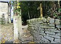
Stone stile on Burnmill Bank
On the west side of the river Derwent at Shotley Bridge. These well-worn steps lead to a footpath along the river.
Image: © Robert Graham
Taken: 31 Oct 2022
0.05 miles