1
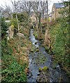
Shotleyfield Burn
This stream flows into the River Derwent here at Shotley Bridge.
Image: © Robert Graham
Taken: 28 Jan 2022
0.02 miles
2
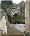
River Derwent at Shotley Bridge
A view from the bridge looking downstream. The large building on the right is a recently completed apartment block which stands on the site of the old flour mill, and closely resembles that building from the outside.
Image: © Robert Graham
Taken: 21 Sep 2020
0.03 miles
3
The River Derwent, Consett
Looking north from the bridge on Burnmill Bank.
Image: © JThomas
Taken: 2 Apr 2016
0.03 miles
4
New housing development beside the river
These houses were built recently on the site of the old flour mill at Shotley Bridge, on the banks of the Derwent. Built in traditional style to match their surroundings.
Image: © Robert Graham
Taken: 28 Mar 2022
0.03 miles
5
Footpath entrance
And a very hard to find one at that. This little flight of steps leads to the footpath alongside the River Derwent at Burnmill Bank, Shotley Bridge. The path leads to Panshields Farm.
Image: © Robert Graham
Taken: 19 Aug 2019
0.04 miles
6
Stone stile on Burnmill Bank
On the west side of the river Derwent at Shotley Bridge. These well-worn steps lead to a footpath along the river.
Image: © Robert Graham
Taken: 31 Oct 2022
0.05 miles
7
Former mill office, Shotley Bridge
This was originally the office for the Derwent Flour Mill which stood on this site. It closed in 1933 and was recently demolished. The office is the only survivor. A new building is being erected on the site. The office has been converted to a private house.
Image: © Robert Graham
Taken: 6 Jul 2018
0.05 miles
8
New building at Shotley Bridge
This is on Wood Street just above the river. This was originally the Derwent Flour Mill which closed in 1933. This new apartment building is being constructed on the same footprint as the old mill and of a similar size. Traditional materials are being used also. This is in the Conservation Area of the village and new building must conform to certain standards.
Image: © Robert Graham
Taken: 6 Jul 2018
0.05 miles
9
The bridge at Shotley
The bridge over the River Derwent which gives the village of Shotley Bridge its name. It is probably 18th century in origin, but the date is unknown. It was widened and repaired in about 1831. Viewed from the east side.
Image: © Robert Graham
Taken: 28 Mar 2022
0.05 miles
10
Shotley Bridge
Image: © Dennis Lovett
Taken: 4 Aug 2005
0.05 miles


