IMAGES TAKEN NEAR TO
Shotley Bridge, CONSETT, DH8 9LT
Introduction
This page details the photographs taken nearby to DH8 9LT by members of the Geograph project.
The Geograph project started in 2005 with the aim of publishing, organising and preserving representative images for every square kilometre of Great Britain, Ireland and the Isle of Man.

There are currently over 7.5m images from over14,400 individuals and you can help contribute to the project by visiting https://www.geograph.org.uk
Image Map
Images are licensed for reuse under creativecommons.org/licenses/by-sa/2.0
Notes
- Clicking on the map will re-center to the selected point.
- The higher the marker number, the further away the image location is from the centre of the postcode.
Image Listing (19 Images Found)
Images are licensed for reuse under creativecommons.org/licenses/by-sa/2.0
Image
Details
Distance
1
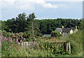
Barley Lodge
Screened from the nearby A68 by a small patch of woodland.
Image: © Pauline E
Taken: 26 Jul 2014
0.01 miles
2

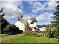
Barley Lodge
Before C20 road straightening, this house stood beside the A68. The 1898 O S map shows the name as Barelawhill, obviously been corrupted since then to the present name.
Image: © Robert Graham
Taken: 16 Aug 2017
0.02 miles
3
Gable view of Barley Lodge
Shown on old maps as Barlawhill Lodge, which shows how names change over time. The building has obviously been extended several times to judge from the roof lines.
Image: © Robert Graham
Taken: 16 Aug 2017
0.02 miles
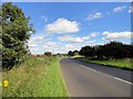
4
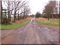
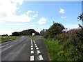
Road at Barley Lodge
Looking north-eastward towards the A68.
Image: © Peter Wood
Taken: 30 Mar 2017
0.02 miles
5
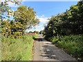
Lane north of Barley Lodge
This was formerly the route of the A68, the old drove road from Scotland. At some time between the Ordnance Survey maps of 1924 and 1949, the road was realigned to take out the sharp bend at Barley Lodge, and this became just an access lane.
Image: © Robert Graham
Taken: 16 Aug 2017
0.04 miles
6
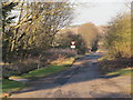
Track to the A68 by Barley Lodge
I guess that this was originally the A68 and that the T junction at Barley Lodge (just behind me) has been bypassed by the sweeping curve of the current main road.
Image: © Mike Quinn
Taken: 9 Jan 2013
0.05 miles
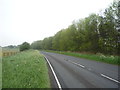
8
View north along the A68
This is the realigned curve at Barley Lodge.
Image: © Robert Graham
Taken: 16 Aug 2017
0.06 miles
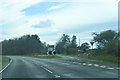
10
Lane off the A68
The lane to the right is the access to Barley Lodge from the main road. As pointed out by Mike Quinn on an earlier photo here, this was once the main road, before the realigned route was added on the left.
Image: © Robert Graham
Taken: 16 Aug 2017
0.07 miles