IMAGES TAKEN NEAR TO
CONSETT, DH8 9HF
Introduction
This page details the photographs taken nearby to DH8 9HF by members of the Geograph project.
The Geograph project started in 2005 with the aim of publishing, organising and preserving representative images for every square kilometre of Great Britain, Ireland and the Isle of Man.

There are currently over 7.5m images from over14,400 individuals and you can help contribute to the project by visiting https://www.geograph.org.uk
Image Map
Images are licensed for reuse under creativecommons.org/licenses/by-sa/2.0
Notes
- Clicking on the map will re-center to the selected point.
- The higher the marker number, the further away the image location is from the centre of the postcode.
Image Listing (15 Images Found)
Images are licensed for reuse under creativecommons.org/licenses/by-sa/2.0
Image
Details
Distance
1
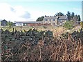
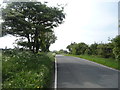
Pondfield Villa on Miller's Hill Lane, Rowley
Viewed from Longedge Lane.
Image: © Oliver Dixon
Taken: 6 Mar 2007
0.00 miles
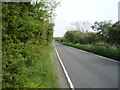
2
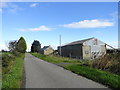
Millershill Lane
Country lane south of Consett. Viewed looking north, past Pondfield Villa.
Image: © Robert Graham
Taken: 24 Sep 2014
0.01 miles
4
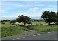
Crossroads on Longedge Lane
Junction of Outputs Lane (to the left) with Longedge Lane, looking East.
Image: © Robert Graham
Taken: 21 Jul 2011
0.09 miles
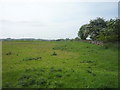
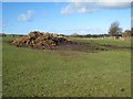
8
Fields beside Millershill Lane
This country lane runs through open fields east of the A68 between Longedge Lane and Eliza Lane. View to the west over grazing pastures for sheep. What look like ruins are on the other side of the wall, but I can't find any signs of a building on old maps.
Image: © Robert Graham
Taken: 2 Apr 2015
0.15 miles
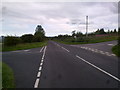
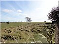
10
Field gate on Longedge Lane
This road goes through farming country south of Consett. The town can be seen in the distance here, looking north. Extensive views from the high ground here.
Image: © Robert Graham
Taken: 13 Jul 2020
0.16 miles