IMAGES TAKEN NEAR TO
CONSETT, DH8 9HE
Introduction
This page details the photographs taken nearby to DH8 9HE by members of the Geograph project.
The Geograph project started in 2005 with the aim of publishing, organising and preserving representative images for every square kilometre of Great Britain, Ireland and the Isle of Man.

There are currently over 7.5m images from over14,400 individuals and you can help contribute to the project by visiting https://www.geograph.org.uk
Image Map
Images are licensed for reuse under creativecommons.org/licenses/by-sa/2.0
Notes
- Clicking on the map will re-center to the selected point.
- The higher the marker number, the further away the image location is from the centre of the postcode.
Image Listing (3 Images Found)
Images are licensed for reuse under creativecommons.org/licenses/by-sa/2.0
Image
Details
Distance
1
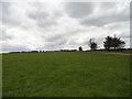
View of China Hall Farm
Looking west from near Hammermill Lane.
Image: © Robert Graham
Taken: 16 Apr 2012
0.01 miles
2
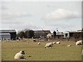
China Hall Farm
Large farm east of the A68. Viewed from Millershill Lane to the east.
Image: © Robert Graham
Taken: 2 Apr 2015
0.01 miles
3
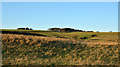
Rough grazing with China House Farm
Barns at China House Farm are seen on the skyline over a rising slope divided into fields of rough grazing.
Image: © Trevor Littlewood
Taken: 2 Dec 2014
0.01 miles