IMAGES TAKEN NEAR TO
Hillfield, CONSETT, DH8 8TE
Introduction
This page details the photographs taken nearby to Hillfield, DH8 8TE by members of the Geograph project.
The Geograph project started in 2005 with the aim of publishing, organising and preserving representative images for every square kilometre of Great Britain, Ireland and the Isle of Man.

There are currently over 7.5m images from over14,400 individuals and you can help contribute to the project by visiting https://www.geograph.org.uk
Image Map
Images are licensed for reuse under creativecommons.org/licenses/by-sa/2.0
Notes
- Clicking on the map will re-center to the selected point.
- The higher the marker number, the further away the image location is from the centre of the postcode.
Image Listing (24 Images Found)
Images are licensed for reuse under creativecommons.org/licenses/by-sa/2.0
Image
Details
Distance
3
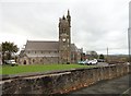
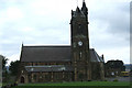
St Mary's R C Church, Blackhill
This was the first Catholic church built in Consett, in 1857. It was built to serve the large Irish Catholic community which had settled in Blackhill. The men came over to work in the steelworks and to escape the potato famine. The architect was Matthias Dunn, who designed the building in Gothic revival style. The clock tower wasn't completed until 1884.
Image: © Robert Graham
Taken: 25 Oct 2017
0.09 miles
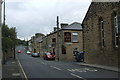
4
The Scotch Arms, Blackhill
Local pub on Derwent Street, in Blackhill, a suburb of Consett.
Image: © Robert Graham
Taken: 25 Oct 2017
0.10 miles
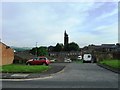
6
View along Church Road , Blackhill
Looking from Durham Road to the spire of St Mary's Church at the end of Church Road.
Image: © Robert Graham
Taken: 1 Sep 2017
0.14 miles
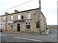
8
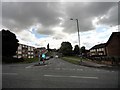
Looking down Derwent Street, Blackhill
View looking north towards Durham Road, the main road through Blackhill.
Image: © Robert Graham
Taken: 25 Oct 2017
0.14 miles
9
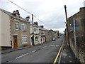
Church Road, Blackhill
Looking up Church Road with the spire of St. Mary's RC Church visible in the distance.
Image: © David P Howard
Taken: 26 Aug 2013
0.17 miles
10
Looking along Church Road in Blackhill
View from Durham Road, the main street in Blackhill. Church Road gets its name from St Mary's Church at the far end, opened in 1857.
Image: © Robert Graham
Taken: 9 Jun 2020
0.17 miles