IMAGES TAKEN NEAR TO
Chaytor Road, CONSETT, DH8 8QT
Introduction
This page details the photographs taken nearby to Chaytor Road, DH8 8QT by members of the Geograph project.
The Geograph project started in 2005 with the aim of publishing, organising and preserving representative images for every square kilometre of Great Britain, Ireland and the Isle of Man.

There are currently over 7.5m images from over14,400 individuals and you can help contribute to the project by visiting https://www.geograph.org.uk
Image Map
Images are licensed for reuse under creativecommons.org/licenses/by-sa/2.0
Notes
- Clicking on the map will re-center to the selected point.
- The higher the marker number, the further away the image location is from the centre of the postcode.
Image Listing (76 Images Found)
Images are licensed for reuse under creativecommons.org/licenses/by-sa/2.0
Image
Details
Distance
1
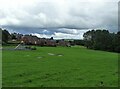
Playing field at Bridgehill
Bridgehill is a large housing estate on the west side of Consett, next to Shotley Bridge. It was built in stages from the 1920's as council housing This section is post WWII.
Image: © Robert Graham
Taken: 6 Jul 2020
0.06 miles
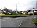
2
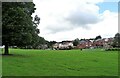
Bridgehill estate
Viewed from Cutler's Hall Road. This large estate on the western side of Consett was constructed in stages from the 1920's onwards. It was mostly council housing initially.
Image: © Robert Graham
Taken: 6 Jul 2020
0.10 miles
3
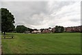
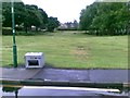
Open green at Bridgehill
Grassed recreation area between Cutlers Hall Road and the north edge of the Bridgehill estate.
Image: © Robert Graham
Taken: 9 Jun 2020
0.12 miles
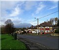
6
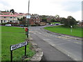
Hardys Corner, Bridgehill
This is the main road into the Bridgehill estate from Cutlers Hall Road in Shotley Bridge. The first houses here were built in the 1920's, part of a major house building program by Consett Council after the First World War. Don't know where the name came from.
Image: © Robert Graham
Taken: 9 Apr 2016
0.14 miles
7
Cutlers Hall Road
Looking down the road beside the green at Bridgehill. The western side of the Derwent valley in the distance, in Northumberland. The river is the County Durham boundary.
Image: © Robert Graham
Taken: 31 Oct 2022
0.15 miles
8
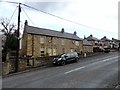
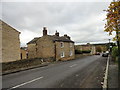
Cutler's Hall, Shotley Bridge
These cottages were built in 1787 for the Oley family, one of the famous Shotley Bridge sword making families. These craftsmen originally came to the area from Germany in the C17 and carried on their trade until the C19. The road here is named Cutler's Hall Road after them.
Image: © Robert Graham
Taken: 9 Apr 2016
0.15 miles
9
Looking down Cutlers Hall Road
View north along this road which runs down the bank from Blackhill into Shotley Bridge.
Image: © Robert Graham
Taken: 25 Oct 2017
0.15 miles
10
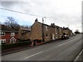
Stone cottages on Cutlers Hall Road
This road in Shotley Bridge was named after the swordmakers who lived here in the C17 to the C19. Cutler's Hall itself is just up the bank from here.
Image: © Robert Graham
Taken: 9 Apr 2016
0.15 miles