IMAGES TAKEN NEAR TO
Derwent Street, CONSETT, DH8 8LT
Introduction
This page details the photographs taken nearby to Derwent Street, DH8 8LT by members of the Geograph project.
The Geograph project started in 2005 with the aim of publishing, organising and preserving representative images for every square kilometre of Great Britain, Ireland and the Isle of Man.

There are currently over 7.5m images from over14,400 individuals and you can help contribute to the project by visiting https://www.geograph.org.uk
Image Map
Images are licensed for reuse under creativecommons.org/licenses/by-sa/2.0
Notes
- Clicking on the map will re-center to the selected point.
- The higher the marker number, the further away the image location is from the centre of the postcode.
Image Listing (47 Images Found)
Images are licensed for reuse under creativecommons.org/licenses/by-sa/2.0
Image
Details
Distance
1
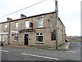
The Scotch Arms, Blackhill
Local pub on Derwent Street, in Blackhill, a suburb of Consett.
Image: © Robert Graham
Taken: 25 Oct 2017
0.04 miles
2
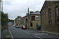
Former bank building, Blackhill
This building is on the corner of Park Road and Bessemer Street. It is now a Christian meeting house but was previously Lloyds Bank.
Image: © Robert Graham
Taken: 15 May 2015
0.06 miles
6
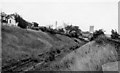
Site of Blackhill Station
View southward, towards Bishop Auckland (via Tow Law) and Durham. Station served by passenger trains from Bishop Auckland (withdrawn north of Tow Law 5/39), Newcastle via Lintz Green until 1/2/54 (goods 11/11/63) and lastly from Newcastle via Birtley and Consett until 23/5/55 when station and lines were closed.
Image: © Ben Brooksbank
Taken: 6 Sep 1970
0.08 miles
7
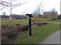
National Cycle Network milepost in Consett
This milepost stands on National Cycle Network route 14 which links Gateshead via the Derwent Path to NCN route 7 (Consett and Sunderland) at Lydgett's Junction, a short way to the south. The milepost finger to the right is pointing to Consett town centre.
The milepost is one of 1000 donated to the National Cycle Network project by the Royal Bank of Scotland. There are four designs of these mileposts - this one is an example of the "Welsh" pattern designed by Welsh artist Andrew Rowe; the design takes inspiration from the nautical and industrial heritage of the artist's native Swansea.
On the far side of the open green are two good examples of roof-mounted solar panels.
Image: © Oliver Dixon
Taken: 28 Feb 2014
0.08 miles
8
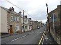
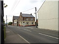
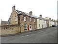
Looking down Derwent Street, Blackhill
View looking north towards Durham Road, the main road through Blackhill.
Image: © Robert Graham
Taken: 25 Oct 2017
0.08 miles
9
Bessemer Street, Blackhill
A reminder of Consett's past as a steel town. The Bessemer process was the first large scale method of producing steel, although I think Consett used the open hearth method mostly.
Image: © Robert Graham
Taken: 25 Oct 2017
0.08 miles
10
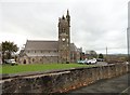
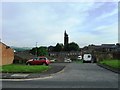
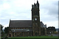
St Mary's R C Church, Blackhill
This was the first Catholic church built in Consett, in 1857. It was built to serve the large Irish Catholic community which had settled in Blackhill. The men came over to work in the steelworks and to escape the potato famine. The architect was Matthias Dunn, who designed the building in Gothic revival style. The clock tower wasn't completed until 1884.
Image: © Robert Graham
Taken: 25 Oct 2017
0.09 miles