IMAGES TAKEN NEAR TO
Pleasant View, CONSETT, DH8 8LE
Introduction
This page details the photographs taken nearby to Pleasant View, DH8 8LE by members of the Geograph project.
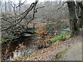
The Geograph project started in 2005 with the aim of publishing, organising and preserving representative images for every square kilometre of Great Britain, Ireland and the Isle of Man.

There are currently over 7.5m images from over14,400 individuals and you can help contribute to the project by visiting https://www.geograph.org.uk
Image Map
Images are licensed for reuse under creativecommons.org/licenses/by-sa/2.0
Notes
- Clicking on the map will re-center to the selected point.
- The higher the marker number, the further away the image location is from the centre of the postcode.
Image Listing (87 Images Found)
Images are licensed for reuse under creativecommons.org/licenses/by-sa/2.0
Image
Details
Distance
1
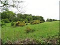
Hillside field at Shotley Grove
There is a strip of pasture and hay fields alongside Shotley Grove Road, on the side of hill below Bridgehill estate.
Image: © Robert Graham
Taken: 9 Jun 2020
0.09 miles
2
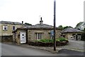
The lodge at Shotley Grove
This was the lodge for Shotley Grove House, seen behind here, which was built in 1828 for John Annandale. He owned the extensive paper mills which stood here on the banks of the Derwent. They are mostly gone, but the house remains.
Image: © Robert Graham
Taken: 9 Jun 2020
0.11 miles
3
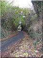
Shotley Grove Lane
View up shotley grove lane running alongside derwent river.
Image: © Colin Edgar
Taken: 6 Nov 2005
0.12 miles
4
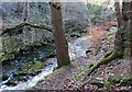
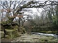
Rocky section of the Derwent at Shotley Grove
The river flows swiftly through a narrow gorge here. The revetments on the far bank must date from the 19th century when there was a lot of industry here.
Image: © Robert Graham
Taken: 9 Jan 2023
0.12 miles
5
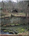
Old culvert in the river bank
On the River Derwent at Shotley Grove. This may have been the exit for a mill race. Although a tranquil scene now, in the 18th & 19th centuries this area was a hive of industry.
Image: © Robert Graham
Taken: 1 Mar 2021
0.12 miles
6
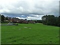
Playing field at Bridgehill
Bridgehill is a large housing estate on the west side of Consett, next to Shotley Bridge. It was built in stages from the 1920's as council housing This section is post WWII.
Image: © Robert Graham
Taken: 6 Jul 2020
0.13 miles
7
Arch Under the Shotley Grove Road
I'm not sure what this is. Seen from across the River Derwent. It's not a bridge there being nothing comparable on the other side of the road. The river bank has been well constructed retaining wall at this point too. Presumably to protect the road from being undermined by river erosion.
Image: © Mick Garratt
Taken: 8 Dec 2007
0.13 miles
8
Rocky gorge on the Derwent
At Shotley Grove.
Image: © Robert Graham
Taken: 1 Mar 2021
0.14 miles
9
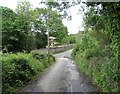
Bottom of Barley Mill Road
This road runs from Pemberton Road, along the west side of Bridgehill and here joins Shotley Grove Road. It becomes more of a country lane as it descends the hillside.
Image: © Robert Graham
Taken: 9 Jun 2020
0.14 miles
10
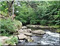
Rocky bed of the River Derwent
The river has cut its way through the rock here, leaving steep little cliffs on either side.
Image: © Robert Graham
Taken: 6 Jul 2020
0.14 miles