IMAGES TAKEN NEAR TO
The Crescent, CONSETT, DH8 8LA
Introduction
This page details the photographs taken nearby to The Crescent, DH8 8LA by members of the Geograph project.
The Geograph project started in 2005 with the aim of publishing, organising and preserving representative images for every square kilometre of Great Britain, Ireland and the Isle of Man.

There are currently over 7.5m images from over14,400 individuals and you can help contribute to the project by visiting https://www.geograph.org.uk
Image Map
Images are licensed for reuse under creativecommons.org/licenses/by-sa/2.0
Notes
- Clicking on the map will re-center to the selected point.
- The higher the marker number, the further away the image location is from the centre of the postcode.
Image Listing (46 Images Found)
Images are licensed for reuse under creativecommons.org/licenses/by-sa/2.0
Image
Details
Distance
1

Barley Mill Crescent, Bridgehill, Consett
Image: © Alex McGregor
Taken: 30 Sep 2010
0.09 miles
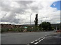
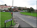
2
Bridgehill
High Ground to left is Grey Mare Hill
Image: © Dennis Lovett
Taken: 2 Aug 2005
0.12 miles
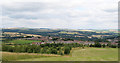
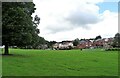
3
Looking over Bridgehill
View looking westwards from Durham Road in Blackhill over the large housing estate of Bridgehill. The woods and fields of the Derwent Valley lie beyond.
Image: © Robert Graham
Taken: 1 Sep 2017
0.13 miles
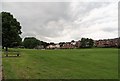
4
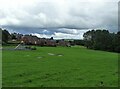
Playing field at Bridgehill
Bridgehill is a large housing estate on the west side of Consett, next to Shotley Bridge. It was built in stages from the 1920's as council housing This section is post WWII.
Image: © Robert Graham
Taken: 6 Jul 2020
0.14 miles
5
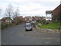
Pleasant View, Bridgehill
Well, it certainly should be for the inhabitants on the left side of the road, looking straight down into the floor of the Derwent Valley.
Image: © Oliver Dixon
Taken: 9 Apr 2007
0.15 miles
6
Bridgehill estate
Viewed from Cutler's Hall Road. This large estate on the western side of Consett was constructed in stages from the 1920's onwards. It was mostly council housing initially.
Image: © Robert Graham
Taken: 6 Jul 2020
0.15 miles
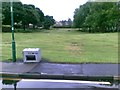
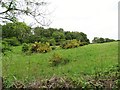
8
Open green at Bridgehill
Grassed recreation area between Cutlers Hall Road and the north edge of the Bridgehill estate.
Image: © Robert Graham
Taken: 9 Jun 2020
0.18 miles
10
Hillside field at Shotley Grove
There is a strip of pasture and hay fields alongside Shotley Grove Road, on the side of hill below Bridgehill estate.
Image: © Robert Graham
Taken: 9 Jun 2020
0.18 miles