IMAGES TAKEN NEAR TO
Gill View, CONSETT, DH8 8ER
Introduction
This page details the photographs taken nearby to Gill View, DH8 8ER by members of the Geograph project.
The Geograph project started in 2005 with the aim of publishing, organising and preserving representative images for every square kilometre of Great Britain, Ireland and the Isle of Man.

There are currently over 7.5m images from over14,400 individuals and you can help contribute to the project by visiting https://www.geograph.org.uk
Image Map
Images are licensed for reuse under creativecommons.org/licenses/by-sa/2.0
Notes
- Clicking on the map will re-center to the selected point.
- The higher the marker number, the further away the image location is from the centre of the postcode.
Image Listing (8 Images Found)
Images are licensed for reuse under creativecommons.org/licenses/by-sa/2.0
Image
Details
Distance
1

Murray Memorials
Monumental mason's premises at The Grove.
Image: © Helen Wilkinson
Taken: 19 May 2007
0.06 miles
2
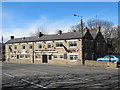
The Stanefordham Inn, Moorside
According to the Evening Gazettes http://evening-gazettes.com/archives/3833 and the Chronicle http://www.chroniclelive.co.uk/north-east-news/evening-chronicle-news/2011/01/19/police-find-40-000-of-cannabis-in-searches-72703-28014275/, the landlord of this pub was recently caught with a £40,000 cannabis farm in one of the bedrooms.
Image: © Mike Quinn
Taken: 5 Apr 2011
0.06 miles
3
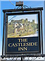
Sign for er... The Stanefordham Inn, Moorside
See Image The pub was formerly known as the Castleside Inn.
Image: © Mike Quinn
Taken: 5 Apr 2011
0.07 miles
4
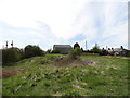
Heathland at Whinney Hill
This little patch of heath stands beside the A692 at Moorside, on the western side of Consett. The old stone building at the top of the bank was probably an agricultural building of some sort.
Image: © Robert Graham
Taken: 4 May 2015
0.11 miles
5
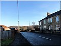
Consett Park Terrace
This is the terrace on the right, beside the A692, the road from Consett to Castleside. It dates from the early 20th century, before WW1, and takes its name form a large farm which once stood in open fields on the other sid eof the road. This was demolished in the 1930's to make way for the Moorside housing estate.
Image: © Robert Graham
Taken: 20 Jan 2020
0.12 miles
6
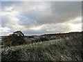
View of Moorside from the old drove path
This path runs north from the A692 to Allensford. In the distance can be seen Moorside Industrial Estate, and beyond is Hownsgill Viaduct.
Image: © Robert Graham
Taken: 25 Oct 2017
0.22 miles
7
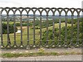
A view from the viaduct
Looking northwards towards Moorside from the Hownsgill Viaduct.
Image: © M J Richardson
Taken: 24 Sep 2009
0.22 miles
8
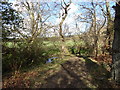
Woods along the Dene Burn
This little burn runs between The Grove and Moorside districts of Consett and into the Derwent near Allensford.
Image: © Robert Graham
Taken: 16 Apr 2012
0.23 miles