IMAGES TAKEN NEAR TO
Chester Road, CONSETT, DH8 8EQ
Introduction
This page details the photographs taken nearby to Chester Road, DH8 8EQ by members of the Geograph project.
The Geograph project started in 2005 with the aim of publishing, organising and preserving representative images for every square kilometre of Great Britain, Ireland and the Isle of Man.

There are currently over 7.5m images from over14,400 individuals and you can help contribute to the project by visiting https://www.geograph.org.uk
Image Map
Images are licensed for reuse under creativecommons.org/licenses/by-sa/2.0
Notes
- Clicking on the map will re-center to the selected point.
- The higher the marker number, the further away the image location is from the centre of the postcode.
Image Listing (15 Images Found)
Images are licensed for reuse under creativecommons.org/licenses/by-sa/2.0
Image
Details
Distance
1
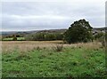
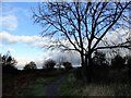
View down the valley from Moorside
Looking down the Derwent Valley from the field path near Moorside.
Image: © Robert Graham
Taken: 19 Oct 2022
0.08 miles
2
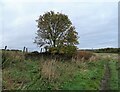
Rowan tree beside the path
Tree in autumn colours and with a good crop of Berries. On the old drove path from Castleside to Allensford.
Image: © Robert Graham
Taken: 19 Oct 2022
0.14 miles
3
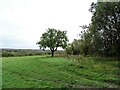
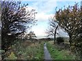
Field path from Moorside
The path along from Moorside leads along the top of the field here, beside the hedge on the right.
Image: © Robert Graham
Taken: 19 Oct 2022
0.16 miles
4
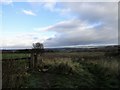
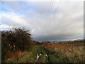
Old gateway
Old tumbledown gateway beside the footpath north from Castleside along the old drove road. View to the north across the north side of the Derwent valley.
Image: © Robert Graham
Taken: 25 Oct 2017
0.17 miles
5
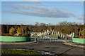
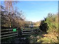
Moorside Cemetery
Moorside Cemetery is a recent development, opened in August 2009; there are few graves there presently (February 2015). Moorside is close to Consett in County Durham and perhaps the design of the gates reflects the steel-making history of that town.
Image: © Trevor Littlewood
Taken: 1 Feb 2015
0.17 miles
6
Looking north along the old drove road
Now just a footpath but the old stone walls on the right show it was once an important route north to Scotland. Much of it is now the A68, but this section was bypassed by the later road.
Image: © Robert Graham
Taken: 25 Oct 2017
0.17 miles
7
Old drove road, Castleside
This runs north from the A692 next to the Horse and Groom pub, which used to be a drovers inn. The road continued north to the crossing of the Derwent at Allensford. It is now just a footpath.
Image: © Robert Graham
Taken: 25 Oct 2017
0.19 miles
8
Field path beside old quarry
This is the footpath north from Castleside running here alongside an old disused quarry.
Image: © Robert Graham
Taken: 25 Oct 2017
0.19 miles
9
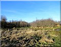
Pond at Castle Hill Wood
This is a small Woodland Trust reserve at Castleside village. The pond is a seasonal one and dries up in the summer.
Image: © Robert Graham
Taken: 20 Jan 2020
0.19 miles
10
Castle Hill Wood
A small nature reserve run by the Woodland Trust on the northern edge of Castleside village. This has been created on a disused quarry as native broadleaved woodland.
Image: © Robert Graham
Taken: 20 Jan 2020
0.21 miles