IMAGES TAKEN NEAR TO
York Place, CONSETT, DH8 8DT
Introduction
This page details the photographs taken nearby to York Place, DH8 8DT by members of the Geograph project.
The Geograph project started in 2005 with the aim of publishing, organising and preserving representative images for every square kilometre of Great Britain, Ireland and the Isle of Man.

There are currently over 7.5m images from over14,400 individuals and you can help contribute to the project by visiting https://www.geograph.org.uk
Image Map
Images are licensed for reuse under creativecommons.org/licenses/by-sa/2.0
Notes
- Clicking on the map will re-center to the selected point.
- The higher the marker number, the further away the image location is from the centre of the postcode.
Image Listing (21 Images Found)
Images are licensed for reuse under creativecommons.org/licenses/by-sa/2.0
Image
Details
Distance
1
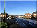
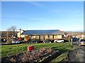
Looking down Derby Drive, Moorside
This long street opens off the A692, the Consett to Castleside road. The large estate at Moorside was started in the 1920's as council housing, and extended later in the 20th century. Derby Drive has the local shops for the estate.
Image: © Robert Graham
Taken: 20 Jan 2020
0.03 miles
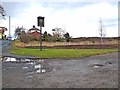
3
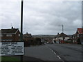
A692 entering Castleside
The blue sign trimmed with yellow shows that Castleside lies ahead: signage typical of settlements in County Durham.
Image: © Trevor Littlewood
Taken: 8 Dec 2021
0.12 miles
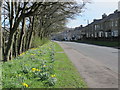
4
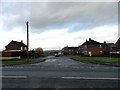
Cambridge Avenue, Moorside
Moorside is a large housing estate on the SW side of Consett. This is the last street on the west side.
Image: © Robert Graham
Taken: 25 Oct 2017
0.16 miles
5

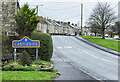
The A692 approaching Moorside
The road sign in typical County Durham style announces that the village of Moorside is being entered; It lies north-east of Castleside. The road beyond passes through another small settlement, The Grove, before reaching Consett.
Image: © Trevor Littlewood
Taken: 8 Oct 2020
0.16 miles
6
R C church at Moorside
On Essex Avenue, beside the A692 on the south side of Consett. This is St Pius X Church, named after an early 20th century pope. Moorside is a large estate of formerly council housing.
Image: © Robert Graham
Taken: 20 Jan 2020
0.17 miles
7
Moorside Hotel, RIP
The sign for the Moorside Hotel Bar and Restaurant still stands beside the busy Consett Road (A692). However, the hotel itself (really just a pub) was demolished about three years ago and apart from the sign the only indication that it ever existed is the tarmac surface of the carpark. Permission has been granted for the construction of fourteen new houses, as yet unexercised.
Image: © Oliver Dixon
Taken: 13 Nov 2012
0.18 miles
9
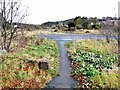
Moorside Hotel, RIP
A sign for the Moorside Hotel Bar and Restaurant still stands beside the busy Consett Road (A692). However, the hotel itself (really just a pub) was demolished about three years ago and apart from the sign the only indication that it ever existed is the tarmac surface of the carpark. The Hownsgill Viaduct can be seen on the skyline Image
Image: © Oliver Dixon
Taken: 13 Nov 2012
0.20 miles
10
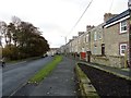
Consett Road, Castleside
The A692 which runs through the village from Consett. The terrace on the right is Maudville.
Image: © Robert Graham
Taken: 25 Oct 2017
0.22 miles