IMAGES TAKEN NEAR TO
Donnington Place, CONSETT, DH8 8DH
Introduction
This page details the photographs taken nearby to Donnington Place, DH8 8DH by members of the Geograph project.
The Geograph project started in 2005 with the aim of publishing, organising and preserving representative images for every square kilometre of Great Britain, Ireland and the Isle of Man.

There are currently over 7.5m images from over14,400 individuals and you can help contribute to the project by visiting https://www.geograph.org.uk
Image Map
Images are licensed for reuse under creativecommons.org/licenses/by-sa/2.0
Notes
- Clicking on the map will re-center to the selected point.
- The higher the marker number, the further away the image location is from the centre of the postcode.
Image Listing (12 Images Found)
Images are licensed for reuse under creativecommons.org/licenses/by-sa/2.0
Image
Details
Distance
1
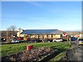
R C church at Moorside
On Essex Avenue, beside the A692 on the south side of Consett. This is St Pius X Church, named after an early 20th century pope. Moorside is a large estate of formerly council housing.
Image: © Robert Graham
Taken: 20 Jan 2020
0.03 miles
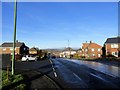
2
Moorside Hotel, RIP
A sign for the Moorside Hotel Bar and Restaurant still stands beside the busy Consett Road (A692). However, the hotel itself (really just a pub) was demolished about three years ago and apart from the sign the only indication that it ever existed is the tarmac surface of the carpark. The Hownsgill Viaduct can be seen on the skyline Image
Image: © Oliver Dixon
Taken: 13 Nov 2012
0.07 miles
3
Moorside Hotel, RIP
The sign for the Moorside Hotel Bar and Restaurant still stands beside the busy Consett Road (A692). However, the hotel itself (really just a pub) was demolished about three years ago and apart from the sign the only indication that it ever existed is the tarmac surface of the carpark. Permission has been granted for the construction of fourteen new houses, as yet unexercised.
Image: © Oliver Dixon
Taken: 13 Nov 2012
0.09 miles
4
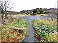
View of Moorside from the old drove path
This path runs north from the A692 to Allensford. In the distance can be seen Moorside Industrial Estate, and beyond is Hownsgill Viaduct.
Image: © Robert Graham
Taken: 25 Oct 2017
0.14 miles
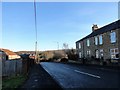
5
Looking down Derby Drive, Moorside
This long street opens off the A692, the Consett to Castleside road. The large estate at Moorside was started in the 1920's as council housing, and extended later in the 20th century. Derby Drive has the local shops for the estate.
Image: © Robert Graham
Taken: 20 Jan 2020
0.15 miles
7
Consett Park Terrace
This is the terrace on the right, beside the A692, the road from Consett to Castleside. It dates from the early 20th century, before WW1, and takes its name form a large farm which once stood in open fields on the other sid eof the road. This was demolished in the 1930's to make way for the Moorside housing estate.
Image: © Robert Graham
Taken: 20 Jan 2020
0.17 miles
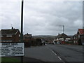
8
A692 entering Castleside
The blue sign trimmed with yellow shows that Castleside lies ahead: signage typical of settlements in County Durham.
Image: © Trevor Littlewood
Taken: 8 Dec 2021
0.20 miles
9
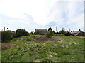
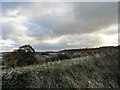
Heathland at Whinney Hill
This little patch of heath stands beside the A692 at Moorside, on the western side of Consett. The old stone building at the top of the bank was probably an agricultural building of some sort.
Image: © Robert Graham
Taken: 4 May 2015
0.22 miles
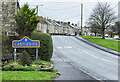
10
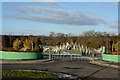
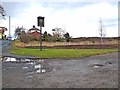
Moorside Cemetery
Moorside Cemetery is a recent development, opened in August 2009; there are few graves there presently (February 2015). Moorside is close to Consett in County Durham and perhaps the design of the gates reflects the steel-making history of that town.
Image: © Trevor Littlewood
Taken: 1 Feb 2015
0.22 miles