IMAGES TAKEN NEAR TO
CONSETT, DH8 7SZ
Introduction
This page details the photographs taken nearby to DH8 7SZ by members of the Geograph project.
The Geograph project started in 2005 with the aim of publishing, organising and preserving representative images for every square kilometre of Great Britain, Ireland and the Isle of Man.

There are currently over 7.5m images from over14,400 individuals and you can help contribute to the project by visiting https://www.geograph.org.uk
Image Map
Images are licensed for reuse under creativecommons.org/licenses/by-sa/2.0
Notes
- Clicking on the map will re-center to the selected point.
- The higher the marker number, the further away the image location is from the centre of the postcode.
Image Listing (14 Images Found)
Images are licensed for reuse under creativecommons.org/licenses/by-sa/2.0
Image
Details
Distance
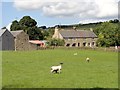
1
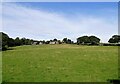
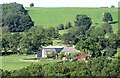
Looking across the field to Lund's House
This farm stands by itself in the countryside west of the village of Iveston.
Image: © Robert Graham
Taken: 14 Sep 2020
0.00 miles
2
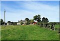
Lund's House farm
Viewed from the field path to the south. These old buildings are probably early 19th century in date.
Image: © Robert Graham
Taken: 14 Sep 2020
0.01 miles
3
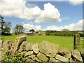
Lunds House Farm from Lund's Lane
This old farm is probably early C19 in origin. Lies in the countryside south of Iveston village.
Image: © Robert Graham
Taken: 11 Jun 2014
0.01 miles
4
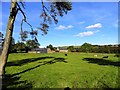
View north from Lund's Lane
Looking towards the farm at Durhamhill Wood, south of Iveston.
Image: © Robert Graham
Taken: 7 Oct 2012
0.02 miles
5
Lunds House farm
Viewed from the south, on Lund's Lane. The farmhouse looks to be a linear type, with originally, byres on the right, now converted to residential. Dates to the early 19th century probably.
Image: © Robert Graham
Taken: 11 Jun 2014
0.02 miles
6
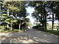
Entrance to Lunds House Farm
This farm is on Lund's Lane, just south of the village of Iveston.
Image: © Robert Graham
Taken: 7 Oct 2012
0.03 miles
8
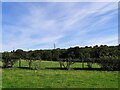
View across the fields to Durhamhill Wood
In the countryside west of the village of Iveston. Mainly grazing land here, next to Lund's House farm.
Image: © Robert Graham
Taken: 14 Sep 2020
0.15 miles
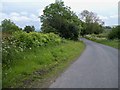
9
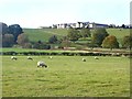
Hillside above Lund's Lane
The top of the hill is crowned by houses on Woodhall Lane, Iveston Image
Image: © Oliver Dixon
Taken: 25 Oct 2018
0.15 miles
10
View of Lunds House from Gorecock Lane
Looking across the fields to the farmstead from the lower end of Gorecock Lane.
Image: © Robert Graham
Taken: 14 Sep 2020
0.17 miles