IMAGES TAKEN NEAR TO
Front Street, CONSETT, DH8 7SE
Introduction
This page details the photographs taken nearby to Front Street, DH8 7SE by members of the Geograph project.
The Geograph project started in 2005 with the aim of publishing, organising and preserving representative images for every square kilometre of Great Britain, Ireland and the Isle of Man.

There are currently over 7.5m images from over14,400 individuals and you can help contribute to the project by visiting https://www.geograph.org.uk
Image Map
Images are licensed for reuse under creativecommons.org/licenses/by-sa/2.0
Notes
- Clicking on the map will re-center to the selected point.
- The higher the marker number, the further away the image location is from the centre of the postcode.
Image Listing (42 Images Found)
Images are licensed for reuse under creativecommons.org/licenses/by-sa/2.0
Image
Details
Distance
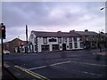
1
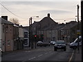
Front Street & Crossroads Leadgate County Durham
Taken on the morning of the 15/03/2017 to capture the sky, I got less sky more of the buildings and traffic.
Image: © Amanda JUDD
Taken: 15 Mar 2017
0.02 miles
2
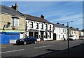
Leadgate Front Street
View down the north side of the main street of Leadgate. These buildings date mainly from the later 19th century, when the village was greatly expanded to house workers in the nearby Consett steelworks and the local coal mines.
Image: © Robert Graham
Taken: 14 Sep 2020
0.02 miles
3
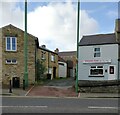
Old houses on New Watling Street
This street runs north from the crossroads in the centre of the village of Leadgate. The name refers to the fact that this was the old Roman Road of Dere Street. Watling Street is a bit of a misnomer, as it is a Roman road in southern England. These old houses are from the original mid-late 19th century founding of the village.
Image: © Robert Graham
Taken: 2 Nov 2021
0.02 miles
4
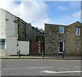
Rear of Front Street in Leadgate
These houses on the left face onto Front Street. This street is New Watling Street, which joins Front Street just out of shot on the left, in the centre of the village.
Image: © Robert Graham
Taken: 2 Nov 2021
0.04 miles
5
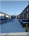
Leadgate Front Street in the snow
Front Street in the village on a bitterly cold December morning. View is east towards the crossroads with the B6309 in the centre of the village.
Image: © Robert Graham
Taken: 13 Dec 2022
0.04 miles
6
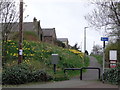
Daffs blowing in breeze,Leadgate County Durham.
Once where Trains use to pass,now part of Cycle two Cycle path network through our Village.12/04/2017 taken before 7.30am.
Image: © Amanda JUDD
Taken: 12 Apr 2017
0.04 miles
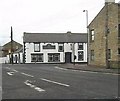
8
The Coach and Horses, Leadgate
This old pub occupies a prominent position at the crossroads in the centre of the village. The road running left to right is the main road through the village from Consett and the crossing road is the road to Durham which follows the line of the Roman road of Dere Street.
Image: © Robert Graham
Taken: 24 Oct 2011
0.04 miles
9
Wren on a wall
At Watling Street, Leadgate, right in the centre of the village.
Image: © Robert Graham
Taken: 2 Nov 2021
0.05 miles
10
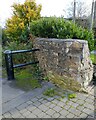
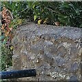
Old wall beside the railway path
A surviving piece of original wall at the junction of the Consett and Sunderland Railway Path with New Watling Street in Leadgate village. You may note the Wren sitting on top of the wall. The safety barrier is to prevent cyclists from riding straight onto the road.
Image: © Robert Graham
Taken: 2 Nov 2021
0.05 miles