IMAGES TAKEN NEAR TO
Durham Road, CONSETT, DH8 7RF
Introduction
This page details the photographs taken nearby to Durham Road, DH8 7RF by members of the Geograph project.
The Geograph project started in 2005 with the aim of publishing, organising and preserving representative images for every square kilometre of Great Britain, Ireland and the Isle of Man.

There are currently over 7.5m images from over14,400 individuals and you can help contribute to the project by visiting https://www.geograph.org.uk
Image Map
Images are licensed for reuse under creativecommons.org/licenses/by-sa/2.0
Notes
- Clicking on the map will re-center to the selected point.
- The higher the marker number, the further away the image location is from the centre of the postcode.
Image Listing (18 Images Found)
Images are licensed for reuse under creativecommons.org/licenses/by-sa/2.0
Image
Details
Distance
2
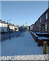
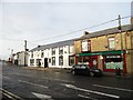
Leadgate Front Street in the snow
Front Street in the village on a bitterly cold December morning. View is east towards the crossroads with the B6309 in the centre of the village.
Image: © Robert Graham
Taken: 13 Dec 2022
0.23 miles
3
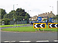
Leadgate, roundabout
A691 meets the A692. B6309 straight across.
Image: © Pauline E
Taken: 16 Sep 2013
0.23 miles
5
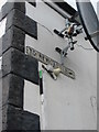
Direction Sign ? Signpost
Located fixed to the wall of the former Coach and Horses PH at first floor level. On the north side of St Ives Road at the junction with the B6309 New Watling Street, in Leadgate. 1 arm only.
Milestone Society National ID: DU_NZ1251
Image: © Mike Rayner
Taken: 28 Jul 2020
0.23 miles
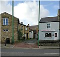
6
St Ives' Road, Leadgate
This street is the main road east from the village crossroads. Of interest is the arched opening in the old stone house, leading through to the rear gardens. There are several of these along the main street.
Image: © Robert Graham
Taken: 20 Jul 2020
0.23 miles
7
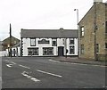
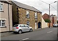
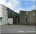
Centre of Leadgate village
This is a view looking west along St Ives Road to the crossroads with the B6309 at the centre of the village. The large black and white building was until recently the Coach and Horses pub. It is now a dog grooming parlour, which has saved the building in its original appearance and given it a needed facelift.
Image: © Robert Graham
Taken: 30 Nov 2016
0.24 miles
8
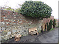
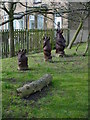
Watling Woods bench, Leadgate
For details of this bench located on the Consett and Sunderland railway path, see Image
Image: © Oliver Dixon
Taken: 29 Apr 2015
0.24 miles
9
Rear of Front Street in Leadgate
These houses on the left face onto Front Street. This street is New Watling Street, which joins Front Street just out of shot on the left, in the centre of the village.
Image: © Robert Graham
Taken: 2 Nov 2021
0.24 miles
10
Old houses on New Watling Street
This street runs north from the crossroads in the centre of the village of Leadgate. The name refers to the fact that this was the old Roman Road of Dere Street. Watling Street is a bit of a misnomer, as it is a Roman road in southern England. These old houses are from the original mid-late 19th century founding of the village.
Image: © Robert Graham
Taken: 2 Nov 2021
0.24 miles