IMAGES TAKEN NEAR TO
South View, CONSETT, DH8 7NT
Introduction
This page details the photographs taken nearby to South View, DH8 7NT by members of the Geograph project.
The Geograph project started in 2005 with the aim of publishing, organising and preserving representative images for every square kilometre of Great Britain, Ireland and the Isle of Man.

There are currently over 7.5m images from over14,400 individuals and you can help contribute to the project by visiting https://www.geograph.org.uk
Image Map
Images are licensed for reuse under creativecommons.org/licenses/by-sa/2.0
Notes
- Clicking on the map will re-center to the selected point.
- The higher the marker number, the further away the image location is from the centre of the postcode.
Image Listing (16 Images Found)
Images are licensed for reuse under creativecommons.org/licenses/by-sa/2.0
Image
Details
Distance
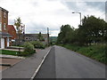
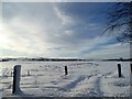
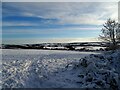
2
Looking down Knitsley Lane in the snow
View south down the lane after heavy snowfall in January.
Image: © Robert Graham
Taken: 9 Jan 2021
0.05 miles
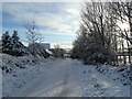
3
Gateway in the snow on Knitsley Lane
Looking west across a snowy landscape at Templetown.
Image: © Robert Graham
Taken: 9 Jan 2021
0.07 miles
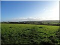
4
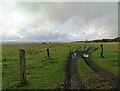
Looking over the fields from Knitsley Lane
This road is on the south side of Consett, going out into the surrounding countryside. Howngill Industrial Estate is on the far side of the field. View over towards the moors in the distance.
Image: © Robert Graham
Taken: 20 Oct 2020
0.07 miles
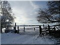
5
Snowy field next to Knitsley Lane
Looking west across the fields beside Knitsley Lane at Templetown after heavy snow in early January.
Image: © Robert Graham
Taken: 9 Jan 2021
0.09 miles
6
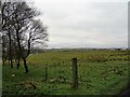
Fields beside Knitsley Lane
View across the fields to the west of the road. There is a view here all the way to the North Pennine moors. Howngill Industrial Estate is on the far right of the picture.
Image: © Robert Graham
Taken: 20 Dec 2021
0.11 miles
7
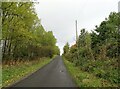
Looking up Knitsley Lane
The lane leads from the countryside into the Templetown area on the south side of Consett.
Image: © Robert Graham
Taken: 20 Oct 2020
0.13 miles
8
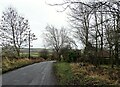
Looking down Knitsley Lane
View south down this lane which leads out into the countryside south of Consett.
Image: © Robert Graham
Taken: 20 Dec 2021
0.19 miles
9
View from Knitsley Lane
Looking over the countryside to the SE down the valley towards Lanchester.
Image: © Robert Graham
Taken: 13 Nov 2020
0.20 miles
10
View east from Knitsley Lane in the snow
Looking across a snow covered landscape. Long view down the valley to Humber Hill near Lanchester.
Image: © Robert Graham
Taken: 9 Jan 2021
0.20 miles