IMAGES TAKEN NEAR TO
Hownsgill Industrial Park, Knitsley Lane, CONSETT, DH8 7BL
Introduction
This page details the photographs taken nearby to Hownsgill Industrial Park, Knitsley Lane, DH8 7BL by members of the Geograph project.
The Geograph project started in 2005 with the aim of publishing, organising and preserving representative images for every square kilometre of Great Britain, Ireland and the Isle of Man.

There are currently over 7.5m images from over14,400 individuals and you can help contribute to the project by visiting https://www.geograph.org.uk
Image Map
Images are licensed for reuse under creativecommons.org/licenses/by-sa/2.0
Notes
- Clicking on the map will re-center to the selected point.
- The higher the marker number, the further away the image location is from the centre of the postcode.
Image Listing (41 Images Found)
Images are licensed for reuse under creativecommons.org/licenses/by-sa/2.0
Image
Details
Distance
1
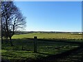
Looking SW from Knitsley Lane
View over the countryside south of Consett town centre. On the right is part of Hownsgill Industrial Estate. This lane leads out into the countryside.
Image: © Robert Graham
Taken: 2 Jan 2023
0.12 miles
2

Consett & Sunderland Railway Path
Part of the National Cycleway No. 7, the Coast to Coast using the dismantled Stanhope & Tyne Railway.
Image: © Mick Garratt
Taken: 1 May 2011
0.12 miles
3
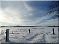
Snowy field next to Knitsley Lane
Looking west across the fields beside Knitsley Lane at Templetown after heavy snow in early January.
Image: © Robert Graham
Taken: 9 Jan 2021
0.14 miles
4

Consett and Sunderland cycle path
The Consett and Sunderland railway path is a component of the C2C cycle route, and carries large numbers of recreational cyclists throughout the year. This section runs between Lydgett Junction and the Consett By-pass
Image: © Oliver Dixon
Taken: 3 Jul 2004
0.14 miles
5
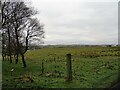
Fields beside Knitsley Lane
View across the fields to the west of the road. There is a view here all the way to the North Pennine moors. Howngill Industrial Estate is on the far right of the picture.
Image: © Robert Graham
Taken: 20 Dec 2021
0.14 miles
6
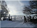
Gateway in the snow on Knitsley Lane
Looking west across a snowy landscape at Templetown.
Image: © Robert Graham
Taken: 9 Jan 2021
0.16 miles
7
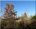
Path side trees
Alongside the Consett & Sunderland Railway Walk. Trees in autumn colours.
Image: © Robert Graham
Taken: 13 Nov 2020
0.17 miles
8
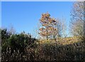
Trees beside the railway path
Winter view alongside the Consett and Sunderland Railway Path near the town centre. A belt of trees and scrubs line this section of the path.
Image: © Robert Graham
Taken: 2 Jan 2023
0.17 miles
9
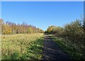
Looking up the Consett railway path
View northeast up the section from Lydgett's Junction to Consett. There is currently (2020) a proposal to reopen this former line to provide a rail link to Tyneside for Consett. Any new line would follow this route, but the prospects aren't that good. It would cost a lot of money.
Image: © Robert Graham
Taken: 13 Nov 2020
0.17 miles
10
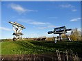
Sculptures beside the railway path, Consett
These very striking giant surveying instruments have become a popular symbol for the town.
Image: © Robert Graham
Taken: 19 Nov 2016
0.18 miles