IMAGES TAKEN NEAR TO
Sunningdale, CONSETT, DH8 7AS
Introduction
This page details the photographs taken nearby to Sunningdale, DH8 7AS by members of the Geograph project.
The Geograph project started in 2005 with the aim of publishing, organising and preserving representative images for every square kilometre of Great Britain, Ireland and the Isle of Man.

There are currently over 7.5m images from over14,400 individuals and you can help contribute to the project by visiting https://www.geograph.org.uk
Image Map
Images are licensed for reuse under creativecommons.org/licenses/by-sa/2.0
Notes
- Clicking on the map will re-center to the selected point.
- The higher the marker number, the further away the image location is from the centre of the postcode.
Image Listing (7 Images Found)
Images are licensed for reuse under creativecommons.org/licenses/by-sa/2.0
Image
Details
Distance
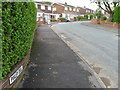
2
Delves Lane road sign
Road sign, road and housing at south end of village
Image: © Vivienne Smith
Taken: 11 Jan 2006
0.14 miles
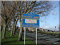
5
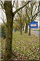
Trees alongside Delves Lane
Delves Lane beside the trees is seen passing through Delves which is a district of Consett.
The blue and yellow sign is in a style found frequently in County Durham. Often, as in this case, these signs have a little additional information about the place that's being entered.
Image: © Trevor Littlewood
Taken: 4 Nov 2015
0.19 miles
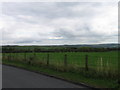
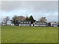
7
View across the fields
From the bottom of Delves Lane, at Consett on a bright winters morning. Pontop Pike and its TV mast can be seen on the horizon in the centre.
Image: © Robert Graham
Taken: 3 Feb 2020
0.24 miles