IMAGES TAKEN NEAR TO
Daisy Hill, CONSETT, DH8 6SB
Introduction
This page details the photographs taken nearby to Daisy Hill, DH8 6SB by members of the Geograph project.
The Geograph project started in 2005 with the aim of publishing, organising and preserving representative images for every square kilometre of Great Britain, Ireland and the Isle of Man.

There are currently over 7.5m images from over14,400 individuals and you can help contribute to the project by visiting https://www.geograph.org.uk
Image Map
Images are licensed for reuse under creativecommons.org/licenses/by-sa/2.0
Notes
- Clicking on the map will re-center to the selected point.
- The higher the marker number, the further away the image location is from the centre of the postcode.
Image Listing (5 Images Found)
Images are licensed for reuse under creativecommons.org/licenses/by-sa/2.0
Image
Details
Distance
1
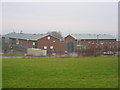
Hassockfield STC
Hassockfield Secure Training Centre main entrance buildings located in old disused quarry.
Image: © Colin Edgar
Taken: 8 Jan 2006
0.20 miles
2
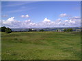
Looking West from Medomsley Edge
View from just North of the crossroads on the B6309. Lovely view of the Pennines on the far horizon.
Image: © Robert Graham
Taken: 10 Jul 2011
0.22 miles
3
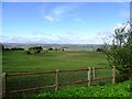
View to the west from Corbridge Road
Roadside view from the B6309 near Medomsley Crossroads. Nice views across the valley to the North Pennines from the top of the valley here.
Image: © Robert Graham
Taken: 15 Apr 2024
0.23 miles
4
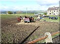
Horses at Medomsley Crossroads
In a rather muddy pasture beside Corbridge Road. Nice view of the north side of the Derwent Valley in the distance.
Image: © Robert Graham
Taken: 15 Apr 2024
0.25 miles
5
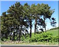
Pine copse beside the road at Elm Park
This is part of a thin strip of Scots Pine woodland between the road and Elm Park Burn, on the eastern edge of Shotley Bridge.
Image: © Robert Graham
Taken: 21 May 2020
0.25 miles