IMAGES TAKEN NEAR TO
Templar Mews, CONSETT, DH8 6QD
Introduction
This page details the photographs taken nearby to Templar Mews, DH8 6QD by members of the Geograph project.
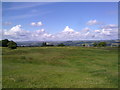
The Geograph project started in 2005 with the aim of publishing, organising and preserving representative images for every square kilometre of Great Britain, Ireland and the Isle of Man.

There are currently over 7.5m images from over14,400 individuals and you can help contribute to the project by visiting https://www.geograph.org.uk
Image Map
Images are licensed for reuse under creativecommons.org/licenses/by-sa/2.0
Notes
- Clicking on the map will re-center to the selected point.
- The higher the marker number, the further away the image location is from the centre of the postcode.
Image Listing (20 Images Found)
Images are licensed for reuse under creativecommons.org/licenses/by-sa/2.0
Image
Details
Distance
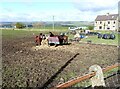
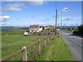
1
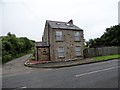
House on Corbridge Road, Medomsley Edge
Standing by itself beside the path leading across the fields to Fines Road in the main village. This path would once have been the entrance to Medomsley Colliery.
Image: © Robert Graham
Taken: 13 Jun 2014
0.01 miles
2
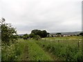
View from east of Cordridge Road, Medomsley Edge
Looking west over the houses of West View to the northern slopes of the Derwent Valley. The track here was originally the road to Medomsley Colliery, now long gone.
Image: © Robert Graham
Taken: 13 Jun 2014
0.04 miles
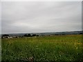
3
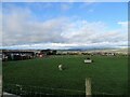
Lone sheep at Medomsley Edge
Sheep with a field to itself beside the path between Corbridge Road and Fines Road at Medomsley. This is the site of the former Medomsley Colliery. Rather nice view in the distance of the Derwent Valley around Whittonstall.
Image: © Robert Graham
Taken: 18 Nov 2020
0.07 miles
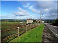
4
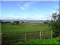
View to the west from Corbridge Road
Roadside view from the B6309 near Medomsley Crossroads. Nice views across the valley to the North Pennines from the top of the valley here.
Image: © Robert Graham
Taken: 15 Apr 2024
0.12 miles
5
Looking West from Medomsley Edge
View from just North of the crossroads on the B6309. Lovely view of the Pennines on the far horizon.
Image: © Robert Graham
Taken: 10 Jul 2011
0.14 miles
6
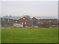
Hassockfield STC
Hassockfield Secure Training Centre main entrance buildings located in old disused quarry.
Image: © Colin Edgar
Taken: 8 Jan 2006
0.15 miles
7
Horses at Medomsley Crossroads
In a rather muddy pasture beside Corbridge Road. Nice view of the north side of the Derwent Valley in the distance.
Image: © Robert Graham
Taken: 15 Apr 2024
0.16 miles
8
View down to Medomsley Crossroads
Looking down Corbridge Road, the B6309, to the crossroads with the B6310.
Image: © Robert Graham
Taken: 15 Apr 2024
0.17 miles
9
View of the crossroads at Medomsley Edge
Looking North along the B6309 to the crossroads. This road is the old Roman Dere Street which ran along here to the fort at Ebchester (Vindamora) and then on to the Roman Wall at Corbridge.
Image: © Robert Graham
Taken: 10 Jul 2011
0.18 miles
10
View north from behind West View at Medomsley Edge
Looking north across hayfields to the north side of the Derwent Valley on the far horizon.
Image: © Robert Graham
Taken: 13 Jun 2014
0.18 miles