IMAGES TAKEN NEAR TO
Rydal Mews, CONSETT, DH8 6EJ
Introduction
This page details the photographs taken nearby to Rydal Mews, DH8 6EJ by members of the Geograph project.
The Geograph project started in 2005 with the aim of publishing, organising and preserving representative images for every square kilometre of Great Britain, Ireland and the Isle of Man.

There are currently over 7.5m images from over14,400 individuals and you can help contribute to the project by visiting https://www.geograph.org.uk
Image Map
Images are licensed for reuse under creativecommons.org/licenses/by-sa/2.0
Notes
- Clicking on the map will re-center to the selected point.
- The higher the marker number, the further away the image location is from the centre of the postcode.
Image Listing (50 Images Found)
Images are licensed for reuse under creativecommons.org/licenses/by-sa/2.0
Image
Details
Distance
1
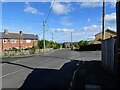
Pont Terrace, Leadgate
The Pont estate was built in the post WW2 period as council housing, on the north side of the existing village.
Image: © Robert Graham
Taken: 26 Sep 2022
0.05 miles
2
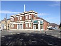
The Roxy, Watling Street, Leadgate
Former cinema in the centre of Leadgate. Opened in 1938, closed in or before 1963. The Roxy project established in 2017 aims to redevelop the old cinema as a theatre and arts centre for the young and disabled.
Image: © Oliver Dixon
Taken: 2 Oct 2018
0.11 miles
3
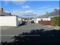
Watling Street Bungalows, Leadgate
These long streets of single storey terraces were built parallel to Watling Street, going down the bank. I think these were probably built by Consett Iron Company between the wars.
Image: © Robert Graham
Taken: 26 Sep 2022
0.11 miles
4
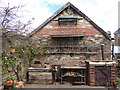
A corner of Watling Woods workshop, Leadgate
A wood carving and wood polishing business beside the Consett and Sunderland railway path.
Image: © Oliver Dixon
Taken: 29 Apr 2015
0.13 miles
5
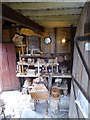
Watling Woods - display of wares
Display of products by a wood carving and wood polishing business beside the Consett and Sunderland railway path.
Image: © Oliver Dixon
Taken: 29 Apr 2015
0.13 miles
6
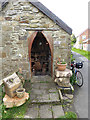
Entrance to Watling Woods workshop, Leadgate
Entrance to wood carving and wood polishing business beside the Consett and Sunderland railway path.
Image: © Oliver Dixon
Taken: 29 Apr 2015
0.13 miles
7
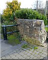
Old wall beside the railway path
A surviving piece of original wall at the junction of the Consett and Sunderland Railway Path with New Watling Street in Leadgate village. You may note the Wren sitting on top of the wall. The safety barrier is to prevent cyclists from riding straight onto the road.
Image: © Robert Graham
Taken: 2 Nov 2021
0.13 miles
8

Square Behind South Cross Street
The Leadgate miners' cottages were built in squares in the 1840's. The original cottages had no toilets or running water, and the squares contained earth closets, one for every 3 cottages, and a communal pump or stand pipe. They were also used for drying washing, storing coal, dumping rubbish and keeping pigs.
Image: © Paul Franks
Taken: 12 May 2015
0.13 miles
9
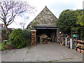
Watling Woods workshop
A wood carving and wood polishing business beside the Consett and Sunderland railway path.
Image: © Oliver Dixon
Taken: 29 Apr 2015
0.13 miles
10

Watling Woods bench, Leadgate
A wood carving and polishing business has been established in a garden adjoining the Consett and Sunderland railway path which also carries the world famous C2C cycle route. Inscriptions on the bench read:
"Joe and Mark helped to make me
This seat was made by some of us for all of us
Can you help?
Art-e-factory and care-takers
Working together with anyone who cares
Carve the bark and polish the spot
Have a go - try - but leave me better than you found me!"
Image: © Oliver Dixon
Taken: 29 Apr 2015
0.14 miles