IMAGES TAKEN NEAR TO
Robson Street, CONSETT, DH8 6AL
Introduction
This page details the photographs taken nearby to Robson Street, DH8 6AL by members of the Geograph project.
The Geograph project started in 2005 with the aim of publishing, organising and preserving representative images for every square kilometre of Great Britain, Ireland and the Isle of Man.

There are currently over 7.5m images from over14,400 individuals and you can help contribute to the project by visiting https://www.geograph.org.uk
Image Map
Images are licensed for reuse under creativecommons.org/licenses/by-sa/2.0
Notes
- Clicking on the map will re-center to the selected point.
- The higher the marker number, the further away the image location is from the centre of the postcode.
Image Listing (17 Images Found)
Images are licensed for reuse under creativecommons.org/licenses/by-sa/2.0
Image
Details
Distance
1
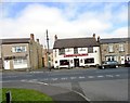
The Grey Horse, Consett
This little pub is quite a favourite with cyclists on the C2C route nearby. Groups can often be seen at the tables outside on Summer afternoons. Also, it brews its own beer, which may add to the attraction.
Image: © Robert Graham
Taken: 20 May 2012
0.11 miles
2
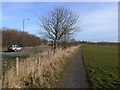
C2C at Consett
The Consett and Sunderland path (part of the famous C2C cycle route, National Cycle Network route 7) for the most part follows the line of the old railway. But here it diverges from the trackbed for about 1 km and runs along this line of trees at the edge of the Crook Hall playing fields. This was the first length of the path to be laid (in 1987). The Consett By-pass (A692), on the Castleside to Chestert-le-Street road runs immediately to the left.
Image: © Oliver Dixon
Taken: 28 Feb 2014
0.14 miles
3
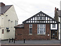
Former register office, Consett
The register office is now in Front Street.
Image: © Pauline E
Taken: 1 Jun 2013
0.16 miles
5
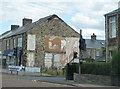
No more spice
The building which once formed the end terrace has been demolished. It was last occupied by Spice Dinner, an Indian Takeaway. Must have been a very hot curry to cause this amount of damage.
Image: © Pauline E
Taken: 25 Jul 2009
0.17 miles
6
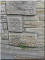
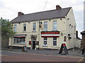
Cut bench mark, Medomsley Road
The building is possibly the Steel Club.
Image: © Pauline E
Taken: 1 Jun 2013
0.17 miles
7
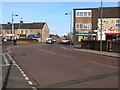
John Street, Consett
Ahead are the traffic lights on Medomsley Road, B6308.
Image: © Oliver Dixon
Taken: 28 Feb 2014
0.18 miles
8
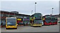
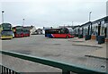
Buses at Consett Bus Station
Virtually all the services from here are operated by Go North East. There was a major modernisation of the local fleet in 2019, with new double deck buses, one of which is shown in the centre here.
Image: © Robert Graham
Taken: 1 Apr 2021
0.20 miles
10
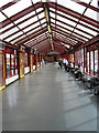
Consett Bus Station
Shown on the right here, this is the third bus station to be built on this site. The buses here are all Go North East vehicles, they operate nearly all the services in the area.
Image: © Robert Graham
Taken: 1 Apr 2021
0.20 miles