IMAGES TAKEN NEAR TO
Goodwood Close, CONSETT, DH8 0UF
Introduction
This page details the photographs taken nearby to Goodwood Close, DH8 0UF by members of the Geograph project.
The Geograph project started in 2005 with the aim of publishing, organising and preserving representative images for every square kilometre of Great Britain, Ireland and the Isle of Man.

There are currently over 7.5m images from over14,400 individuals and you can help contribute to the project by visiting https://www.geograph.org.uk
Image Map
Images are licensed for reuse under creativecommons.org/licenses/by-sa/2.0
Notes
- Clicking on the map will re-center to the selected point.
- The higher the marker number, the further away the image location is from the centre of the postcode.
Image Listing (15 Images Found)
Images are licensed for reuse under creativecommons.org/licenses/by-sa/2.0
Image
Details
Distance
1
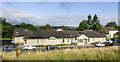
Derwent Clinic
The Derwent Clinic provides mental health services within County Durham and Darlington. It shares a site with the Shotley Bridge Community Hospital.
Image: © Trevor Littlewood
Taken: 15 Aug 2023
0.08 miles
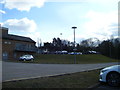
2
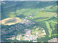
Shotley Bridge Hospital and surrounding area
Aerial shot taken on a pleasure flight in a TB10 light aircraft.
Shotley Bridge hospital - old and new are in the centre foreground.
Image: © Pauline E
Taken: 20 Jun 2005
0.13 miles
4
Shotley Bridge Hospital
View of the old hospital buildings no longer in use today, the current and new hospital buildings out of shot to the left.
Image: © Colin Edgar
Taken: 5 Nov 2005
0.16 miles
6
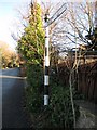
Direction Sign - Signpost by the B6310, Snows Green Road, Shotley Bridge
Pyramid finial - 1 arm; by the B6310, in parish of Consett (Derwentside District), Snows Green Road, Shotley Bridge, junction with Benfieldside Road.
Surveyed
Milestone Society National ID: DU_NZ0953
Image: © Milestone Society
Taken: Unknown
0.20 miles
7
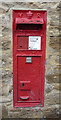
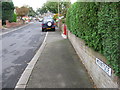
Victorian postbox on Snow's Green Road
Postbox No. DH8 169.
See Image] for context.
Image: © JThomas
Taken: 2 Apr 2016
0.20 miles
8
Houses on Snow's Green Road, Shotley Bridge
Showing position of Victorian Postbox No. DH8 169.
See Image] for postbox.
Image: © JThomas
Taken: 2 Apr 2016
0.20 miles
9
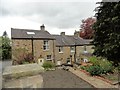
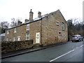
Old cottages at Snows Green
A row of Victorian cottages beside Snows Green Road. This area was a separate farming hamlet before Shotley Bridge expanded in the early C20.
Image: © Robert Graham
Taken: 3 May 2019
0.20 miles
10
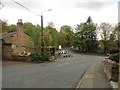
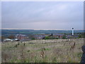
East end of Snows Green Road at Shotley Bridge
The main road goes around a sharp bend on the right up Benfieldside Road. The road on the left leads up the hill to Medomsley. Snows Green was a separate little hamlet prior to the C20.
Image: © Robert Graham
Taken: 3 May 2019
0.22 miles