IMAGES TAKEN NEAR TO
Ebchester, CONSETT, DH8 0PQ
Introduction
This page details the photographs taken nearby to DH8 0PQ by members of the Geograph project.
The Geograph project started in 2005 with the aim of publishing, organising and preserving representative images for every square kilometre of Great Britain, Ireland and the Isle of Man.

There are currently over 7.5m images from over14,400 individuals and you can help contribute to the project by visiting https://www.geograph.org.uk
Image Map
Images are licensed for reuse under creativecommons.org/licenses/by-sa/2.0
Notes
- Clicking on the map will re-center to the selected point.
- The higher the marker number, the further away the image location is from the centre of the postcode.
Image Listing (38 Images Found)
Images are licensed for reuse under creativecommons.org/licenses/by-sa/2.0
Image
Details
Distance
1
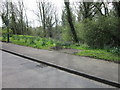
Footpath into Westwood, Ebchester
As the sign indciates owned by the National Trust.
Image: © Clive Nicholson
Taken: 5 Dec 2010
0.04 miles
3
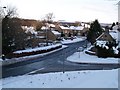
B6309 Staggered Crossroads at Ebchester
Image: © Clive Nicholson
Taken: 5 Dec 2010
0.05 miles
5
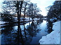
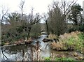
River Derwent at Ebchester
The Derwent seen here looking upstream appears as a substantial river but the water level is artificially high, kept so by the weir running away from the camera through the centre of the image. There's sufficient water to allow boating and just out of view to the left is a boat house.
Image: © Trevor Littlewood
Taken: 15 Apr 2017
0.06 miles
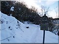
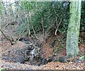
6
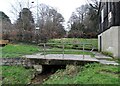
Bottom of the culvert on Ebchester Burn
The burn is culverted for a short distance at the bottom of Ebchester bank, and issues here, just before it flows into the River Derwent.
Image: © Robert Graham
Taken: 13 Dec 2021
0.08 miles
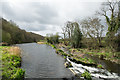
7
The River Derwent at Ebchester
This is just above the weir, looking downstream.
Image: © Robert Graham
Taken: 13 Dec 2021
0.08 miles
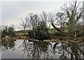
8
Burn flowing into the River Derwent
Ebchester Burn flows into the river here, beside the B6309 road. The old Ebchester Bridge can be seen downstream.
Image: © Robert Graham
Taken: 13 Dec 2021
0.08 miles
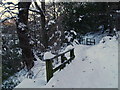
9
Ebchester Burn
This is the lower section of the stream beside the B6309 just before it enters a culvert and then joins the River Derwent. The guard railing is probably there to prevent debris from blocking the culvert and causing a flood.
Image: © Robert Graham
Taken: 13 Dec 2021
0.08 miles