IMAGES TAKEN NEAR TO
Moorlands Crescent, CONSETT, DH8 0JR
Introduction
This page details the photographs taken nearby to Moorlands Crescent, DH8 0JR by members of the Geograph project.
The Geograph project started in 2005 with the aim of publishing, organising and preserving representative images for every square kilometre of Great Britain, Ireland and the Isle of Man.

There are currently over 7.5m images from over14,400 individuals and you can help contribute to the project by visiting https://www.geograph.org.uk
Image Map
Images are licensed for reuse under creativecommons.org/licenses/by-sa/2.0
Notes
- Clicking on the map will re-center to the selected point.
- The higher the marker number, the further away the image location is from the centre of the postcode.
Image Listing (23 Images Found)
Images are licensed for reuse under creativecommons.org/licenses/by-sa/2.0
Image
Details
Distance
1
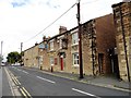
The Miners Arms
On Benfieldside Road, beside the junction with Durham Road in Blackhill.
Image: © Robert Graham
Taken: 1 Sep 2017
0.05 miles
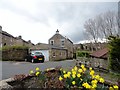
2
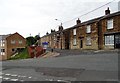
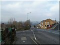
Road junction on Blackhill bank
This is the junction of Benfieldside Road with Durham Road. The pub just along Benfieldside Road, is The Miners Arms, and is shown on the 1862 First Series Ordnance Survey map.
Image: © Robert Graham
Taken: 9 Jun 2020
0.05 miles
3
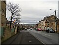
Looking down Blackhill bank
A view west looking down Durham Road. There is a fine view of the Northumberland side of the Derwent Valley in the distance.
Image: © Robert Graham
Taken: 10 Jan 2022
0.07 miles
4
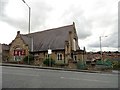
Blackhill Baptist Church
Located at the western end of Durham Road, beside the junction with Pemberton Road.
Image: © Robert Graham
Taken: 1 Sep 2017
0.07 miles
5
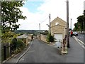
Top of Cutlers Hall Road, Blackhill
Road junction with Pemberton Road to the left, and Benfieldside Road to the right.
Image: © Robert Graham
Taken: 1 Mar 2021
0.07 miles
6
Back street in Benfieldside
This is Backstone Burn, which runs behind Cutlers Hall Road in this western suburb of Consett. View of the Derwent Valley in the distance.
Image: © Robert Graham
Taken: 1 Sep 2017
0.08 miles
7
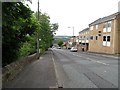
Cutlers Hall Road, Blackhill
Looking down the bank towards Shotley Bridge with a great view at the bottom over the far side of the Derwent Valley.
Image: © Robert Graham
Taken: 9 Jun 2020
0.10 miles
8
Looking down Cutlers Hall Road, Benfieldside
View over the Derwent valley beyond.
Image: © Robert Graham
Taken: 9 Apr 2016
0.11 miles
9
Valley Drive, Bridgehill
On the south side of Cutlers Hall Road.
Image: © Robert Graham
Taken: 9 Apr 2016
0.12 miles
10
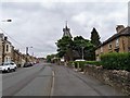
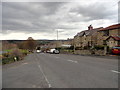
Looking up Durham Road in Blackhill
This is the main shopping street in Blackhill. The tower in the centre belongs to St Andrew's United Reformed Church.
Image: © Robert Graham
Taken: 9 Jun 2020
0.15 miles