IMAGES TAKEN NEAR TO
John Street, CONSETT, DH8 0AD
Introduction
This page details the photographs taken nearby to John Street, DH8 0AD by members of the Geograph project.
The Geograph project started in 2005 with the aim of publishing, organising and preserving representative images for every square kilometre of Great Britain, Ireland and the Isle of Man.

There are currently over 7.5m images from over14,400 individuals and you can help contribute to the project by visiting https://www.geograph.org.uk
Image Map
Images are licensed for reuse under creativecommons.org/licenses/by-sa/2.0
Notes
- Clicking on the map will re-center to the selected point.
- The higher the marker number, the further away the image location is from the centre of the postcode.
Image Listing (29 Images Found)
Images are licensed for reuse under creativecommons.org/licenses/by-sa/2.0
Image
Details
Distance
1
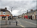
Shops on Durham Road, Blackhill
Looking west down the bank.
Image: © Robert Graham
Taken: 9 Apr 2016
0.10 miles
2
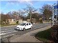
Toucan crossing on Durham Road, Blackhill
This toucan crossing which allows cyclists as well as pedestrians to cross the busy, steep Durham Road, carries National Cycle Network route 14 which links Gateshead via the Derwent Path to NCN route 7 (Consett and Sunderland) at Lydgett's Junction, a short way to the south and also continues along the Lanchester Valley Path towards Durham.
Image: © Oliver Dixon
Taken: 28 Feb 2014
0.11 miles
3
Blackhill Main Street
View down Blackhill towards Bridgehill showing local shops either side.
Image: © Colin Edgar
Taken: 5 Nov 2005
0.11 miles
4
Cycleway alongside Queen's Road, Blackhill
There is a very broad verge on the east side of Queens Road which embraces the old trackbed of the Derwent Valley Railway. Constructed in 1867 and running from Swalwell on the River Tyne up to Consett, the line finally closed in 1963. The footway on the line of the old railway has been converted into a cycleway and forms part of National Cycle Network route 14 which follows a zigzag course from South Shields via Gateshead, Consett, Durham, Hartlepool and Stockton-on-Tees to finish at Darlington.
Image: © Oliver Dixon
Taken: 28 Feb 2014
0.12 miles
5

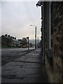
View up the bank at Blackhill
Looking east up Durham Road.
Image: © Robert Graham
Taken: 10 Jan 2022
0.12 miles
6
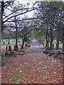
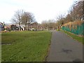
Blackhill Cemetery
View down one aisle in main cemetery area.
Image: © Colin Edgar
Taken: 5 Nov 2005
0.13 miles
7
Queen's Road, Shotley Bridge
Some fine old stone houses along this road. This view shows the junction with King's Road.
Image: © Robert Graham
Taken: 17 Apr 2016
0.13 miles
8
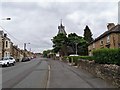
Looking up Durham Road in Blackhill
This is the main shopping street in Blackhill. The tower in the centre belongs to St Andrew's United Reformed Church.
Image: © Robert Graham
Taken: 9 Jun 2020
0.14 miles
9
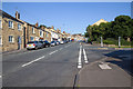
Durham Road, Blackhill
Looking east past the junction of Durham Road with Church Road on the right.
Image: © David P Howard
Taken: 26 Aug 2013
0.14 miles
10
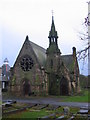
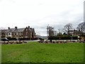
Blackhill Cemetery South
One of three disused and crumbling churches all located together. Other two churches to the right and behind.
Image: © Colin Edgar
Taken: 5 Nov 2005
0.16 miles