IMAGES TAKEN NEAR TO
Kingswood, DURHAM, DH7 9WA
Introduction
This page details the photographs taken nearby to Kingswood, DH7 9WA by members of the Geograph project.
The Geograph project started in 2005 with the aim of publishing, organising and preserving representative images for every square kilometre of Great Britain, Ireland and the Isle of Man.

There are currently over 7.5m images from over14,400 individuals and you can help contribute to the project by visiting https://www.geograph.org.uk
Image Map
Images are licensed for reuse under creativecommons.org/licenses/by-sa/2.0
Notes
- Clicking on the map will re-center to the selected point.
- The higher the marker number, the further away the image location is from the centre of the postcode.
Image Listing (7 Images Found)
Images are licensed for reuse under creativecommons.org/licenses/by-sa/2.0
Image
Details
Distance
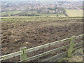
2
Langley Park
A commanding view from Esh village down into the Browney valley
Image: © Oliver Dixon
Taken: 3 Apr 2006
0.18 miles
3
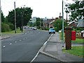
Low Moor Road, Langley Park
Looking west towards the edge of the former mining community.
Image: © Mick Garratt
Taken: 23 Jul 2005
0.21 miles
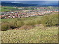
5
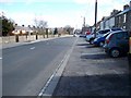
Low Moor Road
Looking East to the village centre.
Image: © David Clark
Taken: 1 Apr 2010
0.22 miles
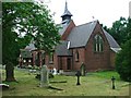
6

All Saints Church, Langley Park
The brick-built church of All Saints lies in the middle of the old 'pit village' of Langley Park. The prominent grave in the foreground records the deaths of several members of a family of which two sons were killed in WWI. The two iron cross grave markers are for young children.
Image: © Trevor Littlewood
Taken: 4 May 2010
0.24 miles
7
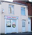
Yummy Yummy Chinese takeaway
Had to snap this one - just because of the name.
Image: © David Clark
Taken: 1 Apr 2010
0.24 miles