IMAGES TAKEN NEAR TO
Stringer Terrace, DURHAM, DH7 9UT
Introduction
This page details the photographs taken nearby to Stringer Terrace, DH7 9UT by members of the Geograph project.
The Geograph project started in 2005 with the aim of publishing, organising and preserving representative images for every square kilometre of Great Britain, Ireland and the Isle of Man.

There are currently over 7.5m images from over14,400 individuals and you can help contribute to the project by visiting https://www.geograph.org.uk
Image Map
Images are licensed for reuse under creativecommons.org/licenses/by-sa/2.0
Notes
- Clicking on the map will re-center to the selected point.
- The higher the marker number, the further away the image location is from the centre of the postcode.
Image Listing (16 Images Found)
Images are licensed for reuse under creativecommons.org/licenses/by-sa/2.0
Image
Details
Distance
1
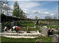
Langley Park Cemetery
Langley Park is an old County Durham 'pit village'. The cemetery is at the W. end of the village and is a considerable size - space for scores of years to come! This view is over plot A to plots B and C beyond to the W.
Image: © Trevor Littlewood
Taken: 4 May 2010
0.05 miles
2

Langley Park Cemetery
Langley Park is an old 'pit village' of north-west County Durham. In this group of graves that of football manager Sir Bobby Robson is right of centre.
Image: © Trevor Littlewood
Taken: 4 May 2010
0.09 miles
3
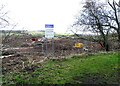
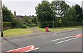
New housing estate at Langley Park
This housing development will see 74 new homes built on farmland on the west side of the village. The village already runs for nearly 2km along the Lanchester Valley Railway Walk, and this extends it right to the old farm at Blackburn. There was a lot of local opposition I believe, but obviously to no avail.
Image: © Robert Graham
Taken: 21 Feb 2022
0.14 miles
4
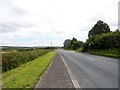
View along Low Moor Road
Looking east towards Langley Park.
Image: © Robert Graham
Taken: 5 Aug 2015
0.16 miles
5
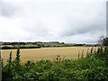
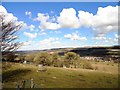
View south from the old railway walk
Looking south from just east of Blackburn across to the escarpment on the south side of the Browney valley. North farm at Esh visible in the distance, and the village itself on the top of the ridge.
Image: © Robert Graham
Taken: 5 Aug 2015
0.18 miles
6
Path to Esh
The footpath leaving Langley Park and heading to the village of Esh.
Image: © Chris Thomas-Atkin
Taken: 23 Jun 2018
0.19 miles
7
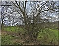
Trees on the side of the old railway
Beside the Lanchester Valley Railway Path at Langley Park. The north side of the valley can be seen in the background.
Image: © Robert Graham
Taken: 21 Feb 2022
0.19 miles
8
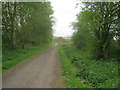
Lanchester Valley Walk
A multi-user route
Image: © Peter Robinson
Taken: 12 May 2013
0.19 miles
9
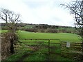
Field gate beside the railway walk
On the north side of the Lanchester Valley Walk at Langley Park, looking across to the north side of the Browney valley.
Image: © Robert Graham
Taken: 21 Feb 2022
0.20 miles
10
Looking north from Groove Bank
View across the Browney Valley from the east end of Esh village. Great view from up here on top of the escarpment. Langley Park is in the valley bottom to the right.
Image: © Robert Graham
Taken: 3 Apr 2013
0.20 miles