IMAGES TAKEN NEAR TO
Low Moor Road, DURHAM, DH7 9UA
Introduction
This page details the photographs taken nearby to Low Moor Road, DH7 9UA by members of the Geograph project.
The Geograph project started in 2005 with the aim of publishing, organising and preserving representative images for every square kilometre of Great Britain, Ireland and the Isle of Man.

There are currently over 7.5m images from over14,400 individuals and you can help contribute to the project by visiting https://www.geograph.org.uk
Image Map
Images are licensed for reuse under creativecommons.org/licenses/by-sa/2.0
Notes
- Clicking on the map will re-center to the selected point.
- The higher the marker number, the further away the image location is from the centre of the postcode.
Image Listing (30 Images Found)
Images are licensed for reuse under creativecommons.org/licenses/by-sa/2.0
Image
Details
Distance
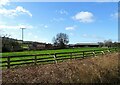
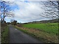
1
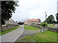
Blackburn farm
View of this farming settlement west of Langley Park.
Image: © Robert Graham
Taken: 5 Aug 2015
0.02 miles
2
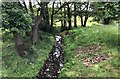
The Blackburn Beck
The Blackburn Beck viewed from the bridge next to Blackburn Farm.
Image: © Chris Thomas-Atkin
Taken: 23 Jun 2018
0.02 miles
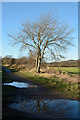
3
Blackburn farm
View of this little settlement from the Lanchester valley walk.
Image: © Robert Graham
Taken: 2 Nov 2011
0.03 miles
4
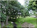
Blackburn Beck
View of this little stream as it runs past the farm of the same name.
Image: © Robert Graham
Taken: 5 Aug 2015
0.03 miles
5
Blackburn farm
View of the farmstead from the Lanchester Valley Walk.
Image: © Robert Graham
Taken: 21 Feb 2022
0.04 miles
6
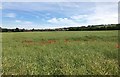
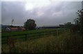
Poppies in the field
Poppies in the field beside the track to Blackburn Farm. In the distance is Langley Park.
Image: © Chris Thomas-Atkin
Taken: 23 Jun 2018
0.07 miles
7
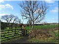
Path to Blackburn from the railway walk
Stile access to the field path to Blackburn farm on the south side of the Lanchester Valley Walk.
Image: © Robert Graham
Taken: 21 Feb 2022
0.08 miles
8
Puddles along the Lanchester Valley Walk
The Lanchester Valley Walk near to the farm at Blackburn. The way is very well used by cyclists as well as walkers as is suggested by the number of wheel traces in the mud at the puddles.
Image: © Trevor Littlewood
Taken: 11 Jan 2014
0.09 miles
9
Looking west along the old railway
This is the Lanchester Valley Walk, along the former branch line to Consett. Burnhope mast can be seen on the horizon in the distance.
Image: © Robert Graham
Taken: 21 Feb 2022
0.09 miles
10
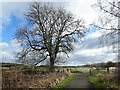
Lone tree beside the railway path
Looking east down the Lanchester Valley Railway Path.
Image: © Robert Graham
Taken: 21 Feb 2022
0.10 miles